IMAGES TAKEN NEAR TO
Courtney Hill, NEWRY, BT34 2EB
Introduction
This page details the photographs taken nearby to Courtney Hill, BT34 2EB by members of the Geograph project.
The Geograph project started in 2005 with the aim of publishing, organising and preserving representative images for every square kilometre of Great Britain, Ireland and the Isle of Man.

There are currently over 7.5m images from over14,400 individuals and you can help contribute to the project by visiting https://www.geograph.org.uk
Image Map
Images are licensed for reuse under creativecommons.org/licenses/by-sa/2.0
Notes
- Clicking on the map will re-center to the selected point.
- The higher the marker number, the further away the image location is from the centre of the postcode.
Image Listing (176 Images Found)
Images are licensed for reuse under creativecommons.org/licenses/by-sa/2.0
Image
Details
Distance
3
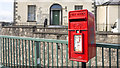
Postbox, Newry
Post mounted Elizabeth II postbox (BT34 24) at Abbey Way in Newry.
Image: © Rossographer
Taken: 19 Apr 2018
0.07 miles
4
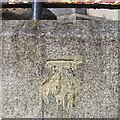
Bench Mark, Newry
Cut bench mark at Abbey Way in Newry. The mark has been levelled to 8.25 metres above MSL.
Image: © Rossographer
Taken: 19 Apr 2018
0.08 miles
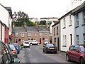
7
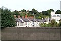
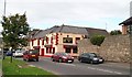
Georgian buildings in William Street, Newry
Image: © Eric Jones
Taken: 9 Sep 2010
0.09 miles
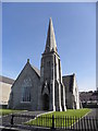
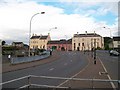
10
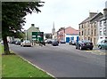
The junction of River Street and Kilmorey Road
Image: © Eric Jones
Taken: 9 Sep 2010
0.11 miles