IMAGES TAKEN NEAR TO
Castle Street, NEWRY, BT34 2BY
Introduction
This page details the photographs taken nearby to Castle Street, BT34 2BY by members of the Geograph project.
The Geograph project started in 2005 with the aim of publishing, organising and preserving representative images for every square kilometre of Great Britain, Ireland and the Isle of Man.

There are currently over 7.5m images from over14,400 individuals and you can help contribute to the project by visiting https://www.geograph.org.uk
Image Map
Images are licensed for reuse under creativecommons.org/licenses/by-sa/2.0
Notes
- Clicking on the map will re-center to the selected point.
- The higher the marker number, the further away the image location is from the centre of the postcode.
Image Listing (472 Images Found)
Images are licensed for reuse under creativecommons.org/licenses/by-sa/2.0
Image
Details
Distance
1
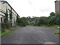
Derelict buildings at the former Sacred Heart Grammar School, Newry
These buildings in Abbey Way adjoin the Poor Clare Convent and have been vacant since the 1980s when the school was rehoused on a green field site at Ashgrove Avenue on the northern outskirts of the city.
Image: © Eric Jones
Taken: 4 Aug 2016
0.01 miles
2
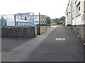
Former buildings of the Sacred Heart Grammar School at the Convent of the Poor Clares
Established in 1930 the school moved to a new site on the outskirts of the city in 1985.
Image: © Eric Jones
Taken: 4 Aug 2016
0.02 miles
3
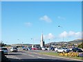
View south along Abbey Way
The spire is that of St Mary's Anglican Church.
Image: © Eric Jones
Taken: 30 Apr 2013
0.03 miles
4
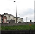
The Poor Clare Convent viewed across Abbey Way
The image was taken from the rear of Newry Cathedral.
Image: © Eric Jones
Taken: 4 Aug 2016
0.04 miles
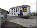
5
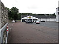
Lidl NI store in the rear of Bagenal's Castle
Image: © Eric Jones
Taken: 4 Aug 2016
0.04 miles
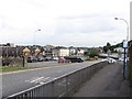
6
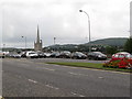
Traffic on Abbey Way, Newry
The spire in the middle ground is that of St Mary's CoI church.
Image: © Eric Jones
Taken: 4 Aug 2016
0.04 miles
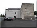
7
The Newry and Mourne Museum on the Bagenal's Castle site
This building was erected as a commercial warehouse in the 19thC and its eastern extension hid much of the frontage of the 16thC tower house known as Bagenal's Castle. Later. the building became a bakery. The Lidl logo at the entrance to the car park advertises the presence of a Lidl store in the Bagenal's Retail Park situated behind the museum.
http://www.newryandmourne.gov.uk/leisure/Attractions/Historical/Bagenals_Castle/Historical_Background.aspx
http://www.bagenalscastle.com/project/mccanns_bakery.asp
Image]
Image: © Eric Jones
Taken: 4 Aug 2016
0.04 miles
8
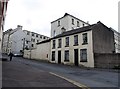
The Poor Clare Convent from the corner of the High Street
Image: © Eric Jones
Taken: 4 Aug 2016
0.04 miles
9
View west along Abbey Way, Newry
Abbey Way provides a by-pass away from?? the very centre of the town.
Image: © Eric Jones
Taken: 4 Aug 2016
0.04 miles
10
Side view of Bagenal's Castle and the Newry and Mourne Museum
The castle dates from the 1560s, while the museum is housed in the larger building, a former warehouse and bakery, which dates from the 19thC. Nicholas Bagenal, a tailor's son and escaped murderer from Staffordshire did well in Ireland and was - when he built this castle as his family dwelling - Edward VI's Marshall of the Army in Ireland.
http://www.bagenalscastle.com/project/nicholas_bagenal.asp
Image: © Eric Jones
Taken: 4 Aug 2016
0.05 miles