IMAGES TAKEN NEAR TO
Windmill Heights, NEWRY, BT34 2AF
Introduction
This page details the photographs taken nearby to Windmill Heights, BT34 2AF by members of the Geograph project.
The Geograph project started in 2005 with the aim of publishing, organising and preserving representative images for every square kilometre of Great Britain, Ireland and the Isle of Man.

There are currently over 7.5m images from over14,400 individuals and you can help contribute to the project by visiting https://www.geograph.org.uk
Image Map
Images are licensed for reuse under creativecommons.org/licenses/by-sa/2.0
Notes
- Clicking on the map will re-center to the selected point.
- The higher the marker number, the further away the image location is from the centre of the postcode.
Image Listing (5 Images Found)
Images are licensed for reuse under creativecommons.org/licenses/by-sa/2.0
Image
Details
Distance
1
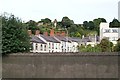
Steps leading to St Patrick's CoI, Newry
The steps climb upwards from the Stream Street gate. This 19thC built church, with its typical CoI tower, stands on the site of the first Protestant church built on the island of Ireland.
http://en.wikipedia.org/wiki/Saint_Patrick's,_Newry
Image: © Eric Jones
Taken: 30 Nov 2016
0.18 miles
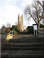
2
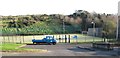
The Ropeworks Synthetic Pitch, Newry
The Ropewalk Synthetic Pitch is based at Three Ways Community Centre in Well Lane.
Image]
Image: © Eric Jones
Taken: 30 Nov 2016
0.23 miles
3
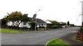
The Beeches, Newry
This residential cul-de-sac runs north off Temple Hill Road.
Image: © Eric Jones
Taken: 7 Nov 2016
0.24 miles
4
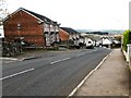
Temple Hill Road descending towards the junction with Church Street, Newry
Temple Hill Road links the village of Ballyholland with the City of Newry.
Image: © Eric Jones
Taken: 7 Nov 2016
0.24 miles