IMAGES TAKEN NEAR TO
Belfast Road, NEWRY, BT34 1TR
Introduction
This page details the photographs taken nearby to Belfast Road, BT34 1TR by members of the Geograph project.
The Geograph project started in 2005 with the aim of publishing, organising and preserving representative images for every square kilometre of Great Britain, Ireland and the Isle of Man.

There are currently over 7.5m images from over14,400 individuals and you can help contribute to the project by visiting https://www.geograph.org.uk
Image Map
Images are licensed for reuse under creativecommons.org/licenses/by-sa/2.0
Notes
- Clicking on the map will re-center to the selected point.
- The higher the marker number, the further away the image location is from the centre of the postcode.
Image Listing (18 Images Found)
Images are licensed for reuse under creativecommons.org/licenses/by-sa/2.0
Image
Details
Distance
1
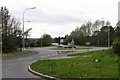
The Damolly Roundabout from Ashgrove Road
This is a roundabout on the A1 (Belfast Road).
Image: © Eric Jones
Taken: 7 Apr 2012
0.07 miles
3
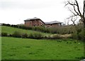
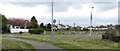
Farmland below the Abbey Grammar School
This image was taken from the north end of Ashgrove Road.
Image: © Eric Jones
Taken: 7 Apr 2012
0.09 miles
4
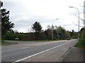
Approaching the Damolly Roundabout on the Newry by-pass
The junction on the left is that of the northern section of Cloghanramer Road.
Image: © Eric Jones
Taken: 7 Apr 2012
0.09 miles
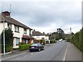
5
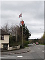
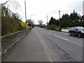
Loyalist symbols on Cloghanramer Road, Newry
While only just under 10% of the population of Newry come from a Protestant background, the percentage in the Windsor Hill 2 ward is as high as 45%.
Image: © Eric Jones
Taken: 7 Apr 2012
0.10 miles
6
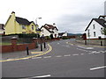
The entrance to the Castleowen Estate
This road leading from Ashgrove Road also provides the main access to the Abbey Grammar School.
Image: © Eric Jones
Taken: 7 Apr 2012
0.10 miles
7
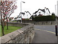
Road junction on the Castleowen Estate
This is a private estate on the northern suburbs of Newry.
Image: © Eric Jones
Taken: 7 Apr 2012
0.13 miles
10
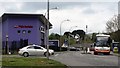
Downshire Road at the junction with Shandon Park
The store on the left - Hein Gerike - is a specialist motor cycle clothing and accessories dealership.
http://www.hein-gericke.co.uk/shops/index/view/id/107/
The bus is the Belfast to Dublin via Dublin Airport service. This practically hourly 24/7 service is shared between the two state bus companies north and south of the border - Ulsterbus Goldline Express (Service 200) and Bus Eireann (Service 1).
http://www.translink.co.uk/Goldline/Goldline-Timetables/Goldline-Service-200-Outbound/
Image: © Eric Jones
Taken: 7 Apr 2012
0.15 miles