IMAGES TAKEN NEAR TO
Drumiller Road, NEWRY, BT34 1TF
Introduction
This page details the photographs taken nearby to Drumiller Road, BT34 1TF by members of the Geograph project.
The Geograph project started in 2005 with the aim of publishing, organising and preserving representative images for every square kilometre of Great Britain, Ireland and the Isle of Man.

There are currently over 7.5m images from over14,400 individuals and you can help contribute to the project by visiting https://www.geograph.org.uk
Image Map
Images are licensed for reuse under creativecommons.org/licenses/by-sa/2.0
Notes
- Clicking on the map will re-center to the selected point.
- The higher the marker number, the further away the image location is from the centre of the postcode.
Image Listing (4 Images Found)
Images are licensed for reuse under creativecommons.org/licenses/by-sa/2.0
Image
Details
Distance
1
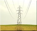
Pylon near Newry
A pylon, on a drumlin, to the east of the disused Newry canal, at Drummiller, north of Newry.
Image: © Albert Bridge
Taken: 28 Feb 2009
0.19 miles
2
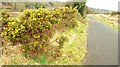
Early whins near Newry
Whin bushes coming into flower beside the Newry canal towpath, to the north of Steenson’s Bridge Image
Image: © Albert Bridge
Taken: 28 Feb 2009
0.23 miles
4
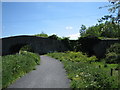
Steenson's Bridge
Over the Newry River (to the left) and the now disused Newry Canal (to the right).
Image: © Brian Shaw
Taken: 1 Jun 2006
0.23 miles