IMAGES TAKEN NEAR TO
Belfast Road, NEWRY, BT34 1QU
Introduction
This page details the photographs taken nearby to Belfast Road, BT34 1QU by members of the Geograph project.
The Geograph project started in 2005 with the aim of publishing, organising and preserving representative images for every square kilometre of Great Britain, Ireland and the Isle of Man.

There are currently over 7.5m images from over14,400 individuals and you can help contribute to the project by visiting https://www.geograph.org.uk
Image Map
Images are licensed for reuse under creativecommons.org/licenses/by-sa/2.0
Notes
- Clicking on the map will re-center to the selected point.
- The higher the marker number, the further away the image location is from the centre of the postcode.
Image Listing (16 Images Found)
Images are licensed for reuse under creativecommons.org/licenses/by-sa/2.0
Image
Details
Distance
1
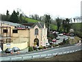
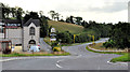
The Sheepbridge Inn
This is a popular restaurant and ten-pin bowling complex which stands on the former A1 Belfast to Dublin road. An adjacent hotel is under construction - Image
Image: © Dean Molyneaux
Taken: 5 Apr 2010
0.01 miles
2
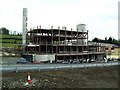
Hotel under construction at Sheepbridge
This is a new hotel extension which is being added onto the popular Sheepbridge restaurant - alongside the A1 Belfast-Dublin road.
Image: © Dean Molyneaux
Taken: 5 Apr 2010
0.02 miles
3
The A1 road approaching the Sheepbridge exit
At present there is a contraflow in operation from Beech Hill to here.
Image: © Dean Molyneaux
Taken: 5 Apr 2010
0.05 miles
4
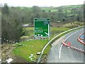
Sign on the A1 at Sheepbridge
This sign is situated on the new A1 dual carriageway (Belfast to Dublin).
At present, all traffic is obliged to exit here and follow the old route around Newry.
A chevron sign on the old road can just be seen to the left of the sign.
Image: © Dean Molyneaux
Taken: 5 Apr 2010
0.06 miles
5
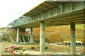
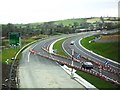
The new Newry bypass (28)
See Image A flyover under construction at the Sheepbridge Road. It will carry a slip road from the bypass (bottom) to a new roundabout on the existing Belfast road Image Continue to Image
Image: © Albert Bridge
Taken: 10 Jan 2009
0.07 miles
6
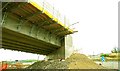
The new Newry bypass (29)
Image: © Albert Bridge
Taken: 10 Jan 2009
0.07 miles
7
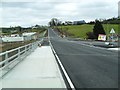
The Belfast Road near the Sheep Bridge, Newry (2)
The Belfast Road, now bypassed http://www.geograph.org.uk/snippet/5285, looking towards Newry. The white car (in the distance) is approximately at the Sheep Bridge Image – one of the best-known landmarks on the old Belfast – Dublin road.
Image: © Albert Bridge
Taken: 26 Aug 2011
0.08 miles
8
Sheepbridge Road after realignment
With the new flyover open, the Sheepbridge Road now meets the Corcreechy Road just north of the Sheepbridge Inn. See Image
Image: © Dean Molyneaux
Taken: 5 Apr 2010
0.09 miles
9
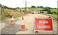
The new Newry bypass (69)
See Image The Sheepbridge Road is currently closed for the duration of the works. The official map, showing the route of the new bypass, suggests that it will re-open. Continue to Image
Image: © Albert Bridge
Taken: 10 Jul 2009
0.09 miles
10
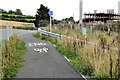
Cycle lane near Newry
The Newry end of the cycle lane seen (middle) in Image
Image: © Albert Bridge
Taken: 26 Aug 2011
0.09 miles