IMAGES TAKEN NEAR TO
Carnacally Road, NEWRY, BT34 1LU
Introduction
This page details the photographs taken nearby to Carnacally Road, BT34 1LU by members of the Geograph project.
The Geograph project started in 2005 with the aim of publishing, organising and preserving representative images for every square kilometre of Great Britain, Ireland and the Isle of Man.

There are currently over 7.5m images from over14,400 individuals and you can help contribute to the project by visiting https://www.geograph.org.uk
Image Map
Images are licensed for reuse under creativecommons.org/licenses/by-sa/2.0
Notes
- Clicking on the map will re-center to the selected point.
- The higher the marker number, the further away the image location is from the centre of the postcode.
Image Listing (15 Images Found)
Images are licensed for reuse under creativecommons.org/licenses/by-sa/2.0
Image
Details
Distance
1
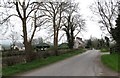
Farm house at the junction of Carnacally Road and Loughorne Road
Image: © Eric Jones
Taken: 13 Mar 2012
0.06 miles
2
Loughorne Road at its junction with Carnacally Road
Image: © Eric Jones
Taken: 13 Mar 2012
0.08 miles
3
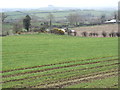
Potato field between Carncally and Loughorne Roads
Image: © Eric Jones
Taken: 13 Mar 2012
0.10 miles
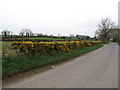
5
Spraying arable land next to the Loughhorne Road
Image: © Eric Jones
Taken: 13 Mar 2012
0.13 miles
6
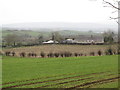
View across farmland to a cottage on Loughorne Road
he image was taken from the Carnacally Road.
Image: © Eric Jones
Taken: 13 Mar 2012
0.14 miles
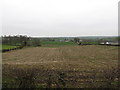
8
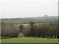
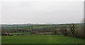
Pasture land east of the Carnacally Road
Inter-drumlin wetland can be seen in the middle ground.
Image: © Eric Jones
Taken: 13 Mar 2012
0.17 miles
9
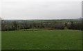
Grazing land east of the Carnacally Road
Image: © Eric Jones
Taken: 13 Mar 2012
0.17 miles
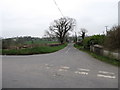
10
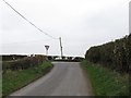
The junction of Rock Road and Carnacally Road
Image: © Eric Jones
Taken: 13 Mar 2012
0.17 miles