IMAGES TAKEN NEAR TO
Elmwood Park, NEWRY, BT34 1LB
Introduction
This page details the photographs taken nearby to Elmwood Park, BT34 1LB by members of the Geograph project.
The Geograph project started in 2005 with the aim of publishing, organising and preserving representative images for every square kilometre of Great Britain, Ireland and the Isle of Man.

There are currently over 7.5m images from over14,400 individuals and you can help contribute to the project by visiting https://www.geograph.org.uk
Image Map
Images are licensed for reuse under creativecommons.org/licenses/by-sa/2.0
Notes
- Clicking on the map will re-center to the selected point.
- The higher the marker number, the further away the image location is from the centre of the postcode.
Image Listing (19 Images Found)
Images are licensed for reuse under creativecommons.org/licenses/by-sa/2.0
Image
Details
Distance
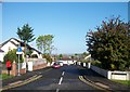
1
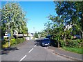
Beechmount Park
There are two separate cul-de-sacs known as Beechwood Park.
Image: © Eric Jones
Taken: 28 May 2010
0.05 miles
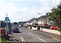
2
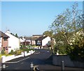
Beechmount Park, Rathfriland Road
Roads in this area are named after trees.
Image: © Eric Jones
Taken: 14 May 2010
0.07 miles
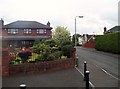
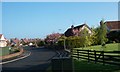
6
Beechmount Park off Rathfriland Road
This is located in the north-eastern suburbs of Newry.
Image: © Eric Jones
Taken: 7 Jun 2018
0.14 miles
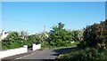
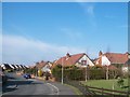
7
Annsville
This is an estate of modern bungalows.
Image: © Eric Jones
Taken: 14 May 2010
0.15 miles
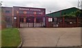
8
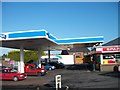
Rockmount Service Station, Rathfriland Road
Image: © Eric Jones
Taken: 14 May 2010
0.16 miles
9
Murdock Hardwood on Rathfriland Road, Newry
Image: © Eric Jones
Taken: 17 Jul 2010
0.16 miles
10
Annsville Estate off Windsor Hill, Newry
Image: © Eric Jones
Taken: 2 Mar 2011
0.16 miles