IMAGES TAKEN NEAR TO
Maryvale Road, NEWRY, BT34 1FH
Introduction
This page details the photographs taken nearby to Maryvale Road, BT34 1FH by members of the Geograph project.
The Geograph project started in 2005 with the aim of publishing, organising and preserving representative images for every square kilometre of Great Britain, Ireland and the Isle of Man.

There are currently over 7.5m images from over14,400 individuals and you can help contribute to the project by visiting https://www.geograph.org.uk
Image Map
Images are licensed for reuse under creativecommons.org/licenses/by-sa/2.0
Notes
- Clicking on the map will re-center to the selected point.
- The higher the marker number, the further away the image location is from the centre of the postcode.
Image Listing (10 Images Found)
Images are licensed for reuse under creativecommons.org/licenses/by-sa/2.0
Image
Details
Distance
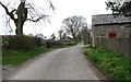
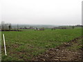
1
Maryvale Road at its junction with Carnacally Road
Image: © Eric Jones
Taken: 13 Mar 2012
0.13 miles
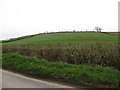
3
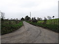
Carnacally Road north of the junction with Maryvale Road
Image: © Eric Jones
Taken: 13 Mar 2012
0.18 miles
4
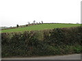
Farm land on Maryvale Hill
This land belongs to Maryvale Farm.
Image: © Eric Jones
Taken: 13 Mar 2012
0.20 miles
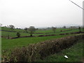
7
Farmland on Maryvale Hill
Maryvale Hill is a large drumlin.
Image: © Eric Jones
Taken: 13 Mar 2012
0.24 miles
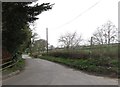
8
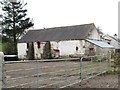
Traditional farm building on the Carnacally Road
Image: © Eric Jones
Taken: 13 Mar 2012
0.24 miles
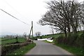
9
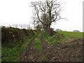
Lane on the east side of Butter Hill
This view was taken from Carnacally Road
Image: © Eric Jones
Taken: 13 Mar 2012
0.24 miles