IMAGES TAKEN NEAR TO
Tullybrannigan Walk, NEWCASTLE, BT33 0TX
Introduction
This page details the photographs taken nearby to Tullybrannigan Walk, BT33 0TX by members of the Geograph project.
The Geograph project started in 2005 with the aim of publishing, organising and preserving representative images for every square kilometre of Great Britain, Ireland and the Isle of Man.

There are currently over 7.5m images from over14,400 individuals and you can help contribute to the project by visiting https://www.geograph.org.uk
Image Map
Images are licensed for reuse under creativecommons.org/licenses/by-sa/2.0
Notes
- Clicking on the map will re-center to the selected point.
- The higher the marker number, the further away the image location is from the centre of the postcode.
Image Listing (215 Images Found)
Images are licensed for reuse under creativecommons.org/licenses/by-sa/2.0
Image
Details
Distance
1
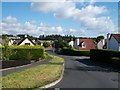
The lower section of Tullybrannigan Rise
The camera is pointing in a south-eastward direction.
Image: © Eric Jones
Taken: 21 Aug 2009
0.03 miles
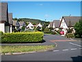
2

Houses in Tullybrannigan Way
Tullybrannigan Rise ends here, with the road dividing to form two closes - Tullybrannigan Way and Tullybrannigan Avenue.
Image: © Eric Jones
Taken: 21 Aug 2009
0.05 miles
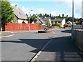
3

Traffic calming measures at the bottom end of Tullybrannigan Rise
Image: © Eric Jones
Taken: 21 Aug 2009
0.05 miles
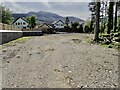
5
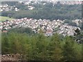
Housing estates between Donard Wood and Tipperary Wood
Image: © Eric Jones
Taken: 6 Sep 2015
0.06 miles
7
Houses in a crescent off Tullybrannigan Rise
Image: © Eric Jones
Taken: 21 Aug 2009
0.06 miles
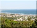
8
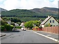
View south-west along Tullybrannigan Rise
The forested Drinnahilly hill forms the background.
Image: © Eric Jones
Taken: 21 Aug 2009
0.07 miles
9
Flood defence wall and flood plain area at the rear of Riverside Park
The aim is to trap in the Tipperary Woods area any flood waters which would top the banks of the Shimna during exceptionally wet weather events and so minimise the threat of flooding in residential areas on the coastal flood plain. A strip of forest land in front of the wall has been cleared of all vegetation.
Image: © Eric Jones
Taken: 7 May 2023
0.10 miles
10
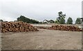
Log stacks by the far end of the Riverside Park Flood Wall
These have been added in the last few days.
Image: © Eric Jones
Taken: 30 Jun 2024
0.10 miles