IMAGES TAKEN NEAR TO
Tullybrannigan Crescent, NEWCASTLE, BT33 0TP
Introduction
This page details the photographs taken nearby to Tullybrannigan Crescent, BT33 0TP by members of the Geograph project.
The Geograph project started in 2005 with the aim of publishing, organising and preserving representative images for every square kilometre of Great Britain, Ireland and the Isle of Man.

There are currently over 7.5m images from over14,400 individuals and you can help contribute to the project by visiting https://www.geograph.org.uk
Image Map
Images are licensed for reuse under creativecommons.org/licenses/by-sa/2.0
Notes
- Clicking on the map will re-center to the selected point.
- The higher the marker number, the further away the image location is from the centre of the postcode.
Image Listing (88 Images Found)
Images are licensed for reuse under creativecommons.org/licenses/by-sa/2.0
Image
Details
Distance
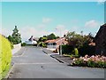
1
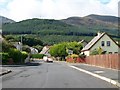
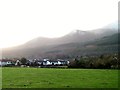
View south-west along Tullybrannigan Rise
The forested Drinnahilly hill forms the background.
Image: © Eric Jones
Taken: 21 Aug 2009
0.02 miles
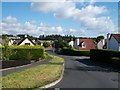
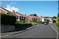
2
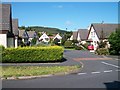
Houses in a crescent off Tullybrannigan Rise
Image: © Eric Jones
Taken: 21 Aug 2009
0.02 miles
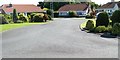
3
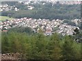
Housing estates between Donard Wood and Tipperary Wood
Image: © Eric Jones
Taken: 6 Sep 2015
0.04 miles
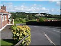
4
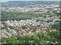
New estates off the Tullybrannigan Road
This view is taken from the track leading to Shepherd's Lodge. Tullybrannigan Road runs left-right in the foreground of the image. The red roofed bungalows are in Tullybrannigan Brae.
Image: © Eric Jones
Taken: 21 Aug 2009
0.06 miles
5
Houses in Kinghill Avenue viewed from Tipperary Lane
Wet snow lies on the upper slopes of Slieve Donard and its acolytes - Millstone Mountain and Thomas Mountain.
Image: © Eric Jones
Taken: 25 Dec 2013
0.07 miles
6
The lower section of Tullybrannigan Rise
The camera is pointing in a south-eastward direction.
Image: © Eric Jones
Taken: 21 Aug 2009
0.07 miles
7
Bungalows on the Tullybrannigan Brae Estate
Image: © Eric Jones
Taken: 21 Aug 2009
0.08 miles
8
Kinghill Avenue descending down to the Kinghill Estate
Image: © Eric Jones
Taken: 21 Aug 2009
0.08 miles
9
The top of Tullybrannigan Rise
The car is heading for the junction with Kinghill Avenue.
Image: © Eric Jones
Taken: 21 Aug 2009
0.09 miles
10
View along the link road between Tullybrannigan Brae and Kinghill Avenue
Image: © Eric Jones
Taken: 21 Aug 2009
0.10 miles