1
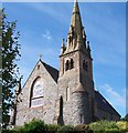
The Church of the Sacred Heart, Dundrum
This Roman Catholic church dominates the northern half of Dundrum, in the same way as St Donard's CofI church dominates the southern end of the village. Unionist emblems characterise the southern half of the village, and GAA flags the northern half.
Image: © Eric Jones
Taken: 12 Sep 2010
0.03 miles
2
Houses at the Quays, Dundrum
Image: © Eric Jones
Taken: 7 Nov 2010
0.03 miles
3
Main Street, Dundrum, north of the junction with Manse Road
Image: © Eric Jones
Taken: 12 Sep 2010
0.03 miles
4
The Squid Shack Takeaway, Main Street, Dundrum
Image: © Eric Jones
Taken: 3 Sep 2021
0.03 miles
5
The Church of the Sacred Heart, Dundrum
The Church of the Sacred Heart is located at the north end of the village.
Image: © Eric Jones
Taken: 12 Sep 2010
0.04 miles
6
Clock House at the junction of Main Street and Manse Road
Built in the early 19thC, this was the office of the Downshire Estates.
Image: © Eric Jones
Taken: 12 Sep 2010
0.04 miles
7
Traffic congestion at the north end of Main Street, Dundrum
The congestion is caused by a combination of Mass-goers making their way to 12 o'clock Mass, visitors to the Sunday market at the car park next to the GAA pitch and through traffic.
http://www.activdownpatrick.com/Classifieds/Content/DundrumCarBootSaleMarket-58.html
Image: © Eric Jones
Taken: 12 Sep 2010
0.04 miles
8
The Church of the Sacred Heart viewed from Castle Hill
The Inner Dundrum Estuary and the Lecale Peninsula form the background.
Image: © Eric Jones
Taken: 12 Sep 2010
0.04 miles
9
Former railway building, Dundrum
The old goods shed has been well restored for residential use. The upper floors were removed.
Image: © Albert Bridge
Taken: 6 May 2013
0.04 miles
10
The Bucks Head, Main Street, Dundrum
Image: © Eric Jones
Taken: 7 Nov 2010
0.04 miles


