IMAGES TAKEN NEAR TO
Seahaven, NEWCASTLE, BT33 0RQ
Introduction
This page details the photographs taken nearby to Seahaven, BT33 0RQ by members of the Geograph project.
The Geograph project started in 2005 with the aim of publishing, organising and preserving representative images for every square kilometre of Great Britain, Ireland and the Isle of Man.

There are currently over 7.5m images from over14,400 individuals and you can help contribute to the project by visiting https://www.geograph.org.uk
Image Map
Images are licensed for reuse under creativecommons.org/licenses/by-sa/2.0
Notes
- Clicking on the map will re-center to the selected point.
- The higher the marker number, the further away the image location is from the centre of the postcode.
Image Listing (914 Images Found)
Images are licensed for reuse under creativecommons.org/licenses/by-sa/2.0
Image
Details
Distance
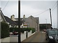
1
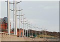
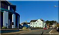
Street lights, Newcastle
See Image These graceful street lights are along the path beside the shore. The Slieve Donard Hotel is on the left.
Image: © Albert Bridge
Taken: 30 Dec 2007
0.01 miles
2
Buildings in Downs Road seen across the grounds of the Slieve Donard Hotel
The Church of Our Lady of the Assumption forms the centrepiece of the image.
Image: © Eric Jones
Taken: 13 Sep 2010
0.02 miles
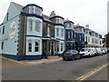
3
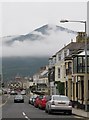
The north end of Downs Road, Newcastle
Low cloud which had plagued the resort for most of the day is slowly lifting up the slopes of Slieve Donard.
Image: © Eric Jones
Taken: 19 May 2014
0.02 miles
4

Newcastle's Promenade north-east of the Shimna Estuary
This view is taken from King Street. The towers of the Waterfoot Apartments and the Presbyterian Church and the parasol-like roof of the Catholic chapel stand out clearly.
Image: © Eric Jones
Taken: 21 Aug 2009
0.02 miles
5
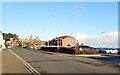
The northern end of Downs Road, Newcastle
Image: © Eric Jones
Taken: 15 Dec 2017
0.02 miles
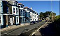
6
Northern end of Downs Road, Newcastle
This road runs parallel with the Northern Promenade. the two main building shown here are the Catholic Church and the private Hutt's Hostel, formerly Newcastle's YHANI hostel.
Image: © Eric Jones
Taken: 17 Jan 2022
0.02 miles
7
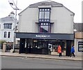
Railway St Cafe and Brew Bar in Railway Street
This is a popular cafe which trades all year round.
Image: © Eric Jones
Taken: 28 Feb 2023
0.02 miles
8
The northern end of Downs Road, Newcastle
This block, north of Donard Place, is occupied by Hutt Hostel (formerly YHANI Hostel), Brunel's Restaurant and The Dunes Apartments.
Image: © Eric Jones
Taken: 28 Feb 2023
0.03 miles
9
The East facing Northern section of Downs Road, Newcastle
The buildings on this stretch of road are The Hutt Backpackers' Hostel, The Brunel Restaurant and the Dunes Apartments. In the background is the entrance to the Slieve Donard Hotel. Downs Road runs parallel with the North Promenade.
Image: © Eric Jones
Taken: 14 Nov 2023
0.03 miles
10
View east along Donard Place
The large pebble-dashed building is the Newcastle Youth Hostel.
Image: © Eric Jones
Taken: 20 Aug 2009
0.03 miles