IMAGES TAKEN NEAR TO
Marguerite Crescent, NEWCASTLE, BT33 0PQ
Introduction
This page details the photographs taken nearby to Marguerite Crescent, BT33 0PQ by members of the Geograph project.
The Geograph project started in 2005 with the aim of publishing, organising and preserving representative images for every square kilometre of Great Britain, Ireland and the Isle of Man.

There are currently over 7.5m images from over14,400 individuals and you can help contribute to the project by visiting https://www.geograph.org.uk
Image Map
Images are licensed for reuse under creativecommons.org/licenses/by-sa/2.0
Notes
- Clicking on the map will re-center to the selected point.
- The higher the marker number, the further away the image location is from the centre of the postcode.
Image Listing (175 Images Found)
Images are licensed for reuse under creativecommons.org/licenses/by-sa/2.0
Image
Details
Distance
1
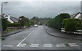
Marguerite Crescent from Marguerite Avenue
Image: © Eric Jones
Taken: 19 Aug 2009
0.01 miles
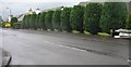
3
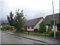
Bungalows at the eastern end of Marguerite Avenue
Image: © Eric Jones
Taken: 19 Aug 2009
0.04 miles
4
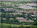
New housing estates on the fringes of Newcastle, Co Down
The image was taken from the north-eastern slopes of Slievenamaddy.
Image: © Eric Jones
Taken: 3 Jun 2015
0.04 miles
5
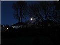
A 95% Waning Gibbous Moon at first light
Image: © Eric Jones
Taken: 27 Dec 2015
0.05 miles
7
View south-westwards along Marguerite Avenue
The Mournes form the background.
Image: © Eric Jones
Taken: 19 Aug 2009
0.05 miles
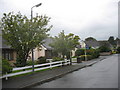
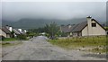
8
The eastern end of Marguerite Avenue, Newcastle
Image: © Eric Jones
Taken: 19 Aug 2009
0.05 miles
9
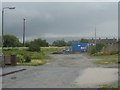
Wasteland between the end of Marguerite Avenue and the Burren River
Image: © Eric Jones
Taken: 19 Aug 2009
0.05 miles
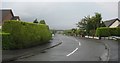
10
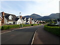
Recently built houses in Marguerite Avenue, Newcastle
The northern flank of the High Mournes forms the background.
Image: © Eric Jones
Taken: 3 Aug 2021
0.05 miles