IMAGES TAKEN NEAR TO
Wateresk Road, NEWCASTLE, BT33 0NN
Introduction
This page details the photographs taken nearby to Wateresk Road, BT33 0NN by members of the Geograph project.
The Geograph project started in 2005 with the aim of publishing, organising and preserving representative images for every square kilometre of Great Britain, Ireland and the Isle of Man.

There are currently over 7.5m images from over14,400 individuals and you can help contribute to the project by visiting https://www.geograph.org.uk
Image Map
Images are licensed for reuse under creativecommons.org/licenses/by-sa/2.0
Notes
- Clicking on the map will re-center to the selected point.
- The higher the marker number, the further away the image location is from the centre of the postcode.
Image Listing (9 Images Found)
Images are licensed for reuse under creativecommons.org/licenses/by-sa/2.0
Image
Details
Distance
3
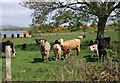
Cattle near the junction with Ballybannon Road
Image: © Eric Jones
Taken: 13 May 2010
0.15 miles
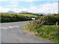
4
The Ballybannon-Wateresk road junction
Ballybannon Road links Wateresk Road with the A25 Castlewellan to Downpatrick Road.
Image: © Eric Jones
Taken: 13 May 2010
0.18 miles
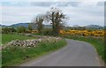
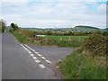
5
The junction of Ballybannan and Wateresk roads
This junction lies north east of the small village of Maghera, Co Down. The Mourne Mountains form the background.
Image: © Eric Jones
Taken: 13 May 2010
0.18 miles
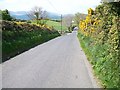
6
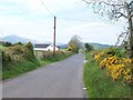
Approaching the Ballybannon road junction from the east
Image: © Eric Jones
Taken: 13 May 2010
0.20 miles
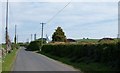
7
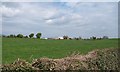
Farmland on the north side of Wateresk Road
Image: © Eric Jones
Taken: 13 May 2010
0.21 miles
8
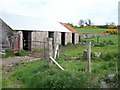
Farm building towards the lower end of Ballybannon Road
Image: © Eric Jones
Taken: 13 May 2010
0.23 miles