IMAGES TAKEN NEAR TO
Wateresk Road, NEWCASTLE, BT33 0NL
Introduction
This page details the photographs taken nearby to Wateresk Road, BT33 0NL by members of the Geograph project.
The Geograph project started in 2005 with the aim of publishing, organising and preserving representative images for every square kilometre of Great Britain, Ireland and the Isle of Man.

There are currently over 7.5m images from over14,400 individuals and you can help contribute to the project by visiting https://www.geograph.org.uk
Image Map
Images are licensed for reuse under creativecommons.org/licenses/by-sa/2.0
Notes
- Clicking on the map will re-center to the selected point.
- The higher the marker number, the further away the image location is from the centre of the postcode.
Image Listing (4 Images Found)
Images are licensed for reuse under creativecommons.org/licenses/by-sa/2.0
Image
Details
Distance
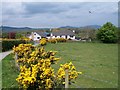
2

The southern end of Priests Road from Wateresk Road near Kilmegan
Priests Road leads north to join the A25 Castlewellan-Clough road.
Image: © Eric Jones
Taken: 13 May 2010
0.19 miles
3
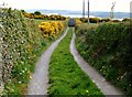
Wateresk Hill Lane
Public rights of way exist along this lane.
Image: © Eric Jones
Taken: 13 May 2010
0.23 miles
4
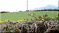
Sheep on the summit of Wateresk Hill
Slieve Donard forms a prominent feature in the background, right.
Image: © Eric Jones
Taken: 13 May 2010
0.24 miles