IMAGES TAKEN NEAR TO
School Hill, NEWCASTLE, BT33 0LZ
Introduction
This page details the photographs taken nearby to School Hill, BT33 0LZ by members of the Geograph project.
The Geograph project started in 2005 with the aim of publishing, organising and preserving representative images for every square kilometre of Great Britain, Ireland and the Isle of Man.

There are currently over 7.5m images from over14,400 individuals and you can help contribute to the project by visiting https://www.geograph.org.uk
Image Map
Images are licensed for reuse under creativecommons.org/licenses/by-sa/2.0
Notes
- Clicking on the map will re-center to the selected point.
- The higher the marker number, the further away the image location is from the centre of the postcode.
Image Listing (126 Images Found)
Images are licensed for reuse under creativecommons.org/licenses/by-sa/2.0
Image
Details
Distance
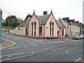
1
Dromara Road, Dundrum, at its junction with the A2 (Main Street)
The building on the right is the former National School.
Image: © Eric Jones
Taken: 16 Nov 2017
0.00 miles
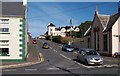
2
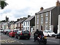
Main Street, Dundrum
Main Street is part of the A2 road.
Image: © Eric Jones
Taken: 12 Sep 2010
0.02 miles
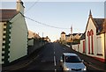
4
School Hill viewed from Main Street
This road leads to Bay View and on to the Dromara Road.
Image: © Eric Jones
Taken: 12 Sep 2010
0.02 miles
5
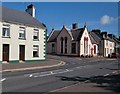
The junction of Main Street and School Hill, Dundrum
The old school cbuilding can be seen at the junction.
Image: © Eric Jones
Taken: 12 Sep 2010
0.03 miles
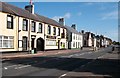
6
The junction of School Hill with Main Street (A2) at the centre of Dundrum
Image: © Eric Jones
Taken: 7 Nov 2010
0.03 miles
7
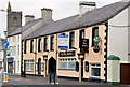
"The Ben Varrey", Dundrum
Not this “Ben Varrey” Image but a former bar and restaurant at Main Street, Dundrum. Now offered for sale and described by the agents as “The site benefits from Full Planning Permission (R/2008/0783/F) which is for the retention and extension of the existing building to form 12 No. 2-Bed apartments and 5No. 3-Bed houses to the rear”. This photograph appears as a matter of record only. I have no connection with any of the parties involved in the sale. To the best of my knowledge “Ben Varrey” is Manx Gaelic for “mermaid”.
Image: © Albert Bridge
Taken: 6 May 2013
0.03 miles
8
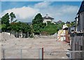
The demolished Ben Varrey PH in Main Street
The site is being redeveloped to provide residential accommodation.
Image]
Image: © Eric Jones
Taken: 10 Jul 2015
0.03 miles
9
Crawling Sunday afternoon traffic in Main Street, Dundrum
Image: © Eric Jones
Taken: 21 Jul 2013
0.03 miles
10
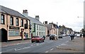
View north eastwards along Dundrum's Main Street
Image: © Eric Jones
Taken: 7 Nov 2010
0.03 miles