IMAGES TAKEN NEAR TO
Bryansford Road, NEWCASTLE, BT33 0LD
Introduction
This page details the photographs taken nearby to Bryansford Road, BT33 0LD by members of the Geograph project.
The Geograph project started in 2005 with the aim of publishing, organising and preserving representative images for every square kilometre of Great Britain, Ireland and the Isle of Man.

There are currently over 7.5m images from over14,400 individuals and you can help contribute to the project by visiting https://www.geograph.org.uk
Image Map
Images are licensed for reuse under creativecommons.org/licenses/by-sa/2.0
Notes
- Clicking on the map will re-center to the selected point.
- The higher the marker number, the further away the image location is from the centre of the postcode.
Image Listing (601 Images Found)
Images are licensed for reuse under creativecommons.org/licenses/by-sa/2.0
Image
Details
Distance
1
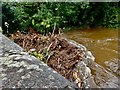
Tree debris in the Shimna trapped against the New Bridge during Storm Francis
Image: © Eric Jones
Taken: 25 Aug 2020
0.00 miles
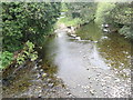
2
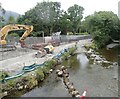
The old ford above the New Bridge
The image also shows work taking place on the Tipperary Lane section of the flood alleviation scheme.
Image: © Eric Jones
Taken: 10 Jul 2022
0.00 miles
3
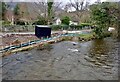
The swollen Shimna above the New Bridge on Christmas Day. 2021
Heavy rain on Christmas Eve saw the river reach its highest level for months. Work on the 'B' section of the flood alleviation scheme is in progress with a new drainage sheugh draining into the Shimna as well as a flood gate being constructed at the vehicle entrance to Tipperary Lane. For the duration of construction Tipperary Lane is out of-bounds to the public.
https://www.infrastructure-ni.gov.uk/publications/shimna-flood-alleviation-scheme-construction-updates
Image: © Eric Jones
Taken: 25 Dec 2021
0.00 miles
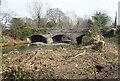
4

The Old Ford at Newcastle's New Bridge
The New Bridge on Bryansford Road dates from the 19th C.
Image: © Eric Jones
Taken: 22 Mar 2022
0.00 miles
5
New pedestrian entry to Tipperary Lane from Bryansford Road
Image: © Eric Jones
Taken: 21 Sep 2022
0.00 miles
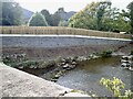
6

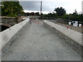
Raised footpath/cycleway linking Tipperary Lane with Bryansford Road
The three arched Victorian bridge on the left is the New Bridge which carries Bryansford Road over the Shimna.
Image: © Eric Jones
Taken: 29 Jan 2023
0.00 miles
7
Disused fording point on the Shimna
This ford was replaced by the New Bridge which carries Bryansford Road across the river. This image was taken from the New Bridge.
Image: © Eric Jones
Taken: 7 May 2019
0.01 miles
8
Tree felling along the Shimna as part of a flood alleviation scheme
Following the disastrous floods of August 2020 tree cover is being removed above and below the New Bridge.
Image: © Eric Jones
Taken: 1 Mar 2021
0.01 miles
9
Completed flood wall and fence at the pedestrian and cycle entrance to Tipperary Lane
The image was taken from the New Bridge.
Image: © Eric Jones
Taken: 8 Oct 2022
0.01 miles
10

Pedestrian and cyclist entrance to Tipperary Lane
The path here has been raised to stop flood water from flowing into Bryansford Road. The parallel vehicle entrance is safeguarded with a steel flood gate. In the event of a flood, water will be trapped in Tipperary Wood.
Image: © Eric Jones
Taken: 8 Oct 2022
0.01 miles