IMAGES TAKEN NEAR TO
Corrigs Road, NEWCASTLE, BT33 0JZ
Introduction
This page details the photographs taken nearby to Corrigs Road, BT33 0JZ by members of the Geograph project.
The Geograph project started in 2005 with the aim of publishing, organising and preserving representative images for every square kilometre of Great Britain, Ireland and the Isle of Man.

There are currently over 7.5m images from over14,400 individuals and you can help contribute to the project by visiting https://www.geograph.org.uk
Image Map
Images are licensed for reuse under creativecommons.org/licenses/by-sa/2.0
Notes
- Clicking on the map will re-center to the selected point.
- The higher the marker number, the further away the image location is from the centre of the postcode.
Image Listing (40 Images Found)
Images are licensed for reuse under creativecommons.org/licenses/by-sa/2.0
Image
Details
Distance
1
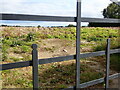
A potato field at Northfield Farm on the Carrigs Road
Image: © Eric Jones
Taken: 18 Sep 2022
0.01 miles
2
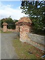
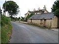
Distinctive brick gate pillars under construction on the Carrigs Road
Image: © Eric Jones
Taken: 18 Sep 2022
0.02 miles
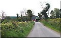
4
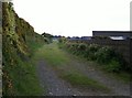
Track leading from the Carrigs Road to the rich farmlands of the reclaimed Corrigs Fen
Image: © Eric Jones
Taken: 18 Sep 2022
0.04 miles
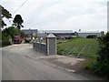
7
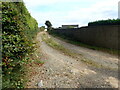
Entrance to Roundwood Precission Engineering on Carrigs Road
Image: © Eric Jones
Taken: 18 Sep 2022
0.07 miles
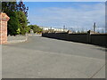
8
View south-eastwards towards the large farm on Carrigs Road
Image: © Eric Jones
Taken: 13 May 2010
0.08 miles
9
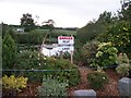
Dangerous ornamental pool on the site of the Northfield Bible Weeks
Image: © Eric Jones
Taken: 14 Jul 2010
0.09 miles
10
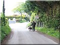
Walking the Greyhounds along Carrig Road
Image: © Eric Jones
Taken: 13 May 2010
0.09 miles