IMAGES TAKEN NEAR TO
Church Hill, NEWCASTLE, BT33 0JU
Introduction
This page details the photographs taken nearby to Church Hill, BT33 0JU by members of the Geograph project.
The Geograph project started in 2005 with the aim of publishing, organising and preserving representative images for every square kilometre of Great Britain, Ireland and the Isle of Man.

There are currently over 7.5m images from over14,400 individuals and you can help contribute to the project by visiting https://www.geograph.org.uk
Image Map
Images are licensed for reuse under creativecommons.org/licenses/by-sa/2.0
Notes
- Clicking on the map will re-center to the selected point.
- The higher the marker number, the further away the image location is from the centre of the postcode.
Image Listing (48 Images Found)
Images are licensed for reuse under creativecommons.org/licenses/by-sa/2.0
Image
Details
Distance
1
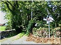
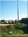
The southern end of Smiley's Loanen
This image was taken from the Church Hill road.
Image: © Eric Jones
Taken: 15 Aug 2020
0.05 miles
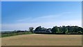
2
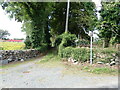
The SE end of a bridle track linking Church Hill and the B180
Image: © Eric Jones
Taken: 18 Sep 2022
0.05 miles
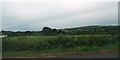
4
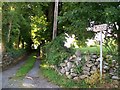
Bridleway linking Church Hill Road and Carnacaville Road
Image: © Eric Jones
Taken: 14 Jul 2010
0.07 miles
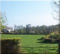
7
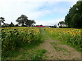
A Field of Sunflowers on Church Hill, Maghera
Image: © Eric Jones
Taken: 18 Sep 2022
0.08 miles
8

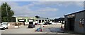
First 4 Floors at the Castlewellan Road Enterprise Zone
Image: © Eric Jones
Taken: 20 Sep 2022
0.09 miles
10
Units on the Castlewellan Road Enterprise Zone
Image: © Eric Jones
Taken: 20 Sep 2022
0.10 miles