IMAGES TAKEN NEAR TO
Slievenamaddy Avenue, NEWCASTLE, BT33 0HX
Introduction
This page details the photographs taken nearby to Slievenamaddy Avenue, BT33 0HX by members of the Geograph project.
The Geograph project started in 2005 with the aim of publishing, organising and preserving representative images for every square kilometre of Great Britain, Ireland and the Isle of Man.

There are currently over 7.5m images from over14,400 individuals and you can help contribute to the project by visiting https://www.geograph.org.uk
Image Map
Images are licensed for reuse under creativecommons.org/licenses/by-sa/2.0
Notes
- Clicking on the map will re-center to the selected point.
- The higher the marker number, the further away the image location is from the centre of the postcode.
Image Listing (74 Images Found)
Images are licensed for reuse under creativecommons.org/licenses/by-sa/2.0
Image
Details
Distance
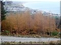
1
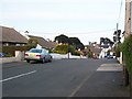
The upper section of Slievenabrock Avenue
Image: © Eric Jones
Taken: 12 May 2010
0.04 miles
2
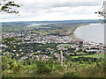
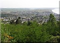
Newcastle from the eastern slopes of Drinnahilly
Image: © Eric Jones
Taken: 27 Jul 2015
0.04 miles
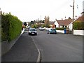
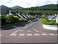
4
Bungalows at the top of Slievenamaddy Road
Image: © Eric Jones
Taken: 21 Aug 2009
0.06 miles
5
The County Down resort of Newcastle from Donard Wood
Newcastle is both a family resort and, because of its proximity to the Mournes, an activities resort.
Image: © Eric Jones
Taken: 29 Apr 2011
0.07 miles
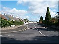
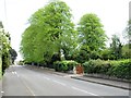
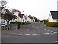
7

The Farnley estate, off Tullybrannigan Road
This is a small new estate.
Image: © Eric Jones
Taken: 20 Aug 2009
0.08 miles
9
Approaching St Colman's CoI graveyard along Tullybrannigan Road
Image: © Eric Jones
Taken: 14 May 2016
0.09 miles
10
The Farnley Estate, Tullybrannigan Road
Image: © Eric Jones
Taken: 12 May 2010
0.09 miles