IMAGES TAKEN NEAR TO
Greenhill Park, NEWCASTLE, BT33 0HP
Introduction
This page details the photographs taken nearby to Greenhill Park, BT33 0HP by members of the Geograph project.
The Geograph project started in 2005 with the aim of publishing, organising and preserving representative images for every square kilometre of Great Britain, Ireland and the Isle of Man.

There are currently over 7.5m images from over14,400 individuals and you can help contribute to the project by visiting https://www.geograph.org.uk
Image Map
Images are licensed for reuse under creativecommons.org/licenses/by-sa/2.0
Notes
- Clicking on the map will re-center to the selected point.
- The higher the marker number, the further away the image location is from the centre of the postcode.
Image Listing (110 Images Found)
Images are licensed for reuse under creativecommons.org/licenses/by-sa/2.0
Image
Details
Distance
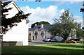
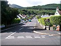
2
Green Hill Park, off Tullybrannigan Road
Image: © Eric Jones
Taken: 21 Aug 2009
0.04 miles
3
Drinnahilly Park leading off Tullybrannigan Road
Image: © Eric Jones
Taken: 21 Aug 2009
0.07 miles
4
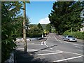
The junction of Tullybrannigan Road with Green Hill Park and Shan Slieve Drive
This image was taken from the upper end of Shan Slieve Drive.
Image: © Eric Jones
Taken: 21 Aug 2009
0.08 miles
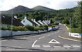
5

Semi-detached houses in the upper part of Shan Slieve Drive
Image: © Eric Jones
Taken: 21 Aug 2009
0.09 miles
6
Houses in Commedagh Park, off Shan Slieve Drive
The transmitter topped Drinihilly forms the background.
Image: © Eric Jones
Taken: 21 Aug 2009
0.09 miles
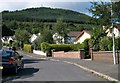
7

Semis in the upper section of Shan Slieve Drive
This view is taken from the bottom of Commedagh Park.
Image: © Eric Jones
Taken: 21 Aug 2009
0.09 miles
8
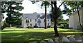
Drinnahilly Gardens Estate
This is a gated town house estate.
Image: © Eric Jones
Taken: 21 Aug 2009
0.10 miles