IMAGES TAKEN NEAR TO
King Street, NEWCASTLE, BT33 0HB
Introduction
This page details the photographs taken nearby to King Street, BT33 0HB by members of the Geograph project.
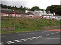
The Geograph project started in 2005 with the aim of publishing, organising and preserving representative images for every square kilometre of Great Britain, Ireland and the Isle of Man.

There are currently over 7.5m images from over14,400 individuals and you can help contribute to the project by visiting https://www.geograph.org.uk
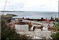
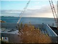
Image Map
Images are licensed for reuse under creativecommons.org/licenses/by-sa/2.0
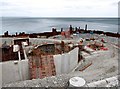
Notes
- Clicking on the map will re-center to the selected point.
- The higher the marker number, the further away the image location is from the centre of the postcode.
Image Listing (326 Images Found)
Images are licensed for reuse under creativecommons.org/licenses/by-sa/2.0
Image
Details
Distance
1
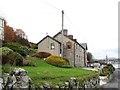
Coastguard Villas, Newcastle
This is a block of modernised cottages housed in the former Victorian-built Newcastle Coastguard Station.
Image: © Eric Jones
Taken: 2 Nov 2016
0.03 miles
2
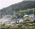
Widow's Row from Newcastle Harbour
This is a terrace of twelve small houses which were built by public subscription to house the widows and orphans of the 46 fishermen lost in the storm of Friday 13th January 1842.
Image: © Eric Jones
Taken: 21 Aug 2009
0.03 miles
3
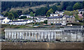
Three landmarks above Newcastle Harbour
On the left is Widow's Row built to house some of the widows of the 73 Co Down fishermen who perished off the Isle of Man in the storm of January 1843. On the right, at same level, are the Customs Cottages which used to house the water-guard and their families. This building has been converted into apartments. In the foreground is the Newcastle Foul Water Treatment Works which underwent major extensions between 2011 and 2016.
Image: © Eric Jones
Taken: 28 Apr 2021
0.05 miles
4
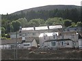
Houses above Newcastle Harbour
The hill slope in the background is that of Thomas's Mountain.
Image: © Eric Jones
Taken: 21 Aug 2009
0.05 miles
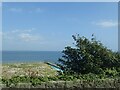
5
Houses above the Harbour at Newcastle
The image was taken from the Kilkeel Road.
Image: © Eric Jones
Taken: 11 Sep 2010
0.05 miles
6
The construction of an extension to the Newcastle Sewage Works
A cofferdam has been erected around the site to keep out the Irish Sea.
Image: © Eric Jones
Taken: 13 May 2012
0.06 miles
7
The site of the extension to the Newcastle Sewage Works
Image: © Eric Jones
Taken: 13 May 2012
0.06 miles
8
New sewage works under construction at Newcastle Harbour
Image: © Eric Jones
Taken: 29 Sep 2012
0.06 miles
9
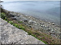
Rocky coastline below the Kilkeel Road (A2)
These rocks belong to the Hawick Group of Silurian origin.
Image: © Eric Jones
Taken: 13 May 2012
0.06 miles
10
Garden on the flat roof of Newcastle's Waste Water Treatment Works
Image: © Eric Jones
Taken: 30 Aug 2024
0.06 miles