IMAGES TAKEN NEAR TO
South Promenade, NEWCASTLE, BT33 0EX
Introduction
This page details the photographs taken nearby to South Promenade, BT33 0EX by members of the Geograph project.
The Geograph project started in 2005 with the aim of publishing, organising and preserving representative images for every square kilometre of Great Britain, Ireland and the Isle of Man.

There are currently over 7.5m images from over14,400 individuals and you can help contribute to the project by visiting https://www.geograph.org.uk
Image Map
Images are licensed for reuse under creativecommons.org/licenses/by-sa/2.0
Notes
- Clicking on the map will re-center to the selected point.
- The higher the marker number, the further away the image location is from the centre of the postcode.
Image Listing (358 Images Found)
Images are licensed for reuse under creativecommons.org/licenses/by-sa/2.0
Image
Details
Distance
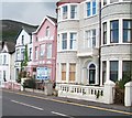
1

Newcastle's Central Promenade
In the background, the Mountains of Mourne sweep down to the sea.
Image: © Eric Jones
Taken: 12 Jul 2012
0.00 miles
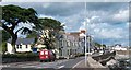
2

The A2 at The Rock, Newcastle
The A2 runs along the coast of Northern Ireland from Newry to Derry/Londonderry. Here, Slieve Donard, Northern Ireland's highest mountain. forms the background.
Image: © Eric Jones
Taken: 13 Sep 2020
0.00 miles
4
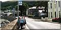
A chat at the bus stop on the South Promenade
Image: © Eric Jones
Taken: 21 Aug 2009
0.01 miles

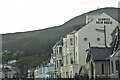
7

The Soak Seaweed Baths spa on the South Promenade
Image: © Eric Jones
Taken: 8 Feb 2018
0.02 miles
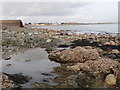
9
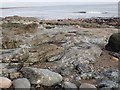
Silurian greywacke shale outcrops below the South Promenade
Image: © Eric Jones
Taken: 8 Feb 2018
0.03 miles