IMAGES TAKEN NEAR TO
Sally Gardens, NEWCASTLE, BT33 0ET
Introduction
This page details the photographs taken nearby to Sally Gardens, BT33 0ET by members of the Geograph project.
The Geograph project started in 2005 with the aim of publishing, organising and preserving representative images for every square kilometre of Great Britain, Ireland and the Isle of Man.

There are currently over 7.5m images from over14,400 individuals and you can help contribute to the project by visiting https://www.geograph.org.uk
Image Map
Images are licensed for reuse under creativecommons.org/licenses/by-sa/2.0
Notes
- Clicking on the map will re-center to the selected point.
- The higher the marker number, the further away the image location is from the centre of the postcode.
Image Listing (19 Images Found)
Images are licensed for reuse under creativecommons.org/licenses/by-sa/2.0
Image
Details
Distance
1
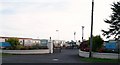
The entrance to the Sunnyholme Caravan Park, Castlewellan Road
Image: © Eric Jones
Taken: 21 Aug 2009
0.02 miles
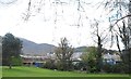
2
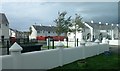
Burren Meadow Housing Estate, Castlewellan Road, Newcastle
This is a large social housing estate recently built by the NI Housing Executive.
Image: © Eric Jones
Taken: 9 Oct 2018
0.07 miles
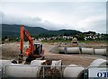
3
Drainage pipes on the site of the new housing estate on Castlewellan Road
The land chosen for this social housing project is poorly drained and subject to periodic flooding. Special emphasis appears to been given to providing an adequate drainage system for the site.
Image: © Eric Jones
Taken: 14 Apr 2012
0.09 miles
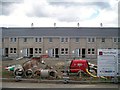
4
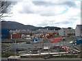
New Housing Executive Estate in Castlewellan Road
This Northern Ireland Housing Executive Social Housing Projects involves the building of 130 units comprising of 67 flats and 63 houses.
Image: © Eric Jones
Taken: 14 Apr 2012
0.09 miles
5
New Social Housing Provision in Castlewellan Road
Image: © Eric Jones
Taken: 14 Apr 2012
0.09 miles
6
Laying drainage pipes on a building site in Castlewellan Road
This is the site of a new general needs social housing estate. This development of 135 houses will cost some £20 million.
Image: © Eric Jones
Taken: 20 Jul 2011
0.10 miles
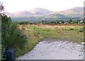
7
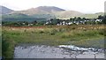
View westwards across the flood plain of the Burren River
The new Meadowvale Estate can be seen on the other side of the valley.
Image: © Eric Jones
Taken: 21 Aug 2009
0.10 miles
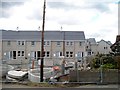
8
Terraced housing under construction on the Housing Executive Estate on Castlewellan Road
Image: © Eric Jones
Taken: 14 Apr 2012
0.10 miles
9
Waste ground west of the Castlewellan Road (A50)
Image: © Eric Jones
Taken: 21 Aug 2009
0.11 miles
10
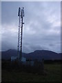
Newly constructed Mobile cell site at J3732.
The Mountains of Mourne standing proudly in the foreground on a bitterly cold morning.
Image: © Peter Lyons
Taken: 15 Jan 2008
0.11 miles