IMAGES TAKEN NEAR TO
Spelga Avenue, NEWCASTLE, BT33 0DR
Introduction
This page details the photographs taken nearby to Spelga Avenue, BT33 0DR by members of the Geograph project.
The Geograph project started in 2005 with the aim of publishing, organising and preserving representative images for every square kilometre of Great Britain, Ireland and the Isle of Man.

There are currently over 7.5m images from over14,400 individuals and you can help contribute to the project by visiting https://www.geograph.org.uk
Image Map
Images are licensed for reuse under creativecommons.org/licenses/by-sa/2.0
Notes
- Clicking on the map will re-center to the selected point.
- The higher the marker number, the further away the image location is from the centre of the postcode.
Image Listing (413 Images Found)
Images are licensed for reuse under creativecommons.org/licenses/by-sa/2.0
Image
Details
Distance
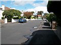
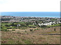
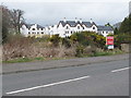
2
View south along Spelga Avenue
Spelga Avenue links Tullybrannigan Road and Bryansford Road.
Image: © Eric Jones
Taken: 21 Aug 2009
0.04 miles
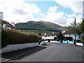
3
The junction of Spelga Avenue and Slievenamaddy Avenue
Slieve Donard forms the background.
Image: © Eric Jones
Taken: 19 Feb 2010
0.05 miles
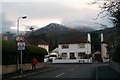
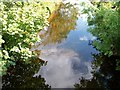
4
Radiation fog forming over the Tullybrannigan area of Newcastle
Radiation fog can form in mountain valleys when a temperature inversion caused by heavier cold air settling into a valley, with warmer air passing over the mountains above. In this case the fog is thickened by smoke from countless chimneys. Newcastle, like much of Northern Ireland, has no piped natural gas so most homes have a coal fire. A snow capped Slieve Donard provides the background. The same day as this image was created BBC news was reporting gale force winds and torrential rainfall over much of the British mainland.
Image: © Eric Jones
Taken: 25 Nov 2012
0.05 miles
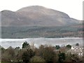
5
The urban fringe of the coastal resort of Newcastle from the Spinkwee path
Where the Mournes end, Newcastle begins.
Image: © Eric Jones
Taken: 5 May 2012
0.05 miles
6
The placid Tullybranigan River above the Bryansford Road bridge
Heavy rain over the Mournes can turn this river into a raging torrent.
Image: © Eric Jones
Taken: 21 Aug 2009
0.06 miles
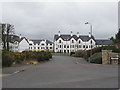
7
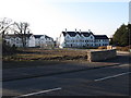
Apartment Buildings off Bryansford Road, Newcastle
These are recently built apartment buildings.
Image: © Eric Jones
Taken: 16 Mar 2011
0.06 miles
8
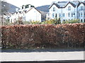
Apartment buildings in Brooklands Grove, Newcastle
Image: © Eric Jones
Taken: 9 Mar 2016
0.06 miles
9
Brooklands Grove Apartments on Shimna Road
Image: © Eric Jones
Taken: 17 Mar 2017
0.06 miles
10
Apartments in Brooklands Grove off Shimna Road
Image: © Eric Jones
Taken: 17 Mar 2017
0.06 miles