IMAGES TAKEN NEAR TO
Golf Links Road, NEWCASTLE, BT33 0AN
Introduction
This page details the photographs taken nearby to Golf Links Road, BT33 0AN by members of the Geograph project.
The Geograph project started in 2005 with the aim of publishing, organising and preserving representative images for every square kilometre of Great Britain, Ireland and the Isle of Man.

There are currently over 7.5m images from over14,400 individuals and you can help contribute to the project by visiting https://www.geograph.org.uk
Image Map
Images are licensed for reuse under creativecommons.org/licenses/by-sa/2.0
Notes
- Clicking on the map will re-center to the selected point.
- The higher the marker number, the further away the image location is from the centre of the postcode.
Image Listing (677 Images Found)
Images are licensed for reuse under creativecommons.org/licenses/by-sa/2.0
Image
Details
Distance
1
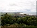
Newcastle and Dundrum Bay from the view point at Curraghard
Image: © Eric Jones
Taken: 11 Jul 2010
0.02 miles
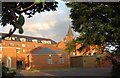
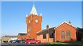
2
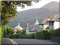
View south along Golf Links Road
The parasol roof of Our Lady of the Assumption and the former railway station building spire can be seen against the great bulk of Slieve Donard.
Image: © Eric Jones
Taken: 21 Aug 2009
0.03 miles
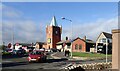
3
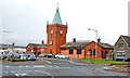
Former railway station, Newcastle
See Image The former railway station (altered but not excessively) is now a supermarket. The present bus station is on the left.
Image: © Albert Bridge
Taken: 10 Oct 2008
0.03 miles
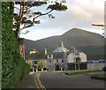
4
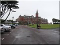
Slieve Donard Hotel, Newcastle
An impressive building
Image: © Kenneth Allen
Taken: 3 Aug 2009
0.04 miles
5
The rear of the Slieve Donard Hotel at Newcastle, Co Down
This view is taken from Golf Links Road.
Image: © Eric Jones
Taken: 21 Aug 2009
0.04 miles
6
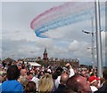
The Red Arrows thrilling the throng on Newcastle's Promenade
The Red Arrows sweeping above the promenade. The brick-built building in the background is the Slieve Donard Hotel.
Image: © Eric Jones
Taken: 6 Aug 2011
0.04 miles
7
Lidl's Supermarket
This occupies the buildings of the former railway station.
Image: © Eric Jones
Taken: 19 Feb 2011
0.04 miles
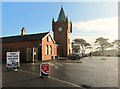
8
The junction of Golf Links Road and Railway Street, Newcastle
Image: © Eric Jones
Taken: 21 Aug 2009
0.05 miles
9
Lidl's Supermarket in Railway Street
For almost a century this was the terminus of the railway line from Belfast.
Image: © Eric Jones
Taken: 19 Feb 2011
0.05 miles
10
Newcastle's former railway station in Railway Street
The station was closed in the 1950's and eventually became the town's Lidl Supermarket. Some 5 years ago, Lidl porchased the site of the former St Mary's Catholic School on the southern outskirts of the town with the intention of relocating to this more extensive site but since then little progress has been made.
Image: © Eric Jones
Taken: 14 Nov 2023
0.05 miles