IMAGES TAKEN NEAR TO
Glen Road, BANBRIDGE, BT32 5PN
Introduction
This page details the photographs taken nearby to Glen Road, BT32 5PN by members of the Geograph project.
The Geograph project started in 2005 with the aim of publishing, organising and preserving representative images for every square kilometre of Great Britain, Ireland and the Isle of Man.

There are currently over 7.5m images from over14,400 individuals and you can help contribute to the project by visiting https://www.geograph.org.uk
Image Map
Images are licensed for reuse under creativecommons.org/licenses/by-sa/2.0
Notes
- Clicking on the map will re-center to the selected point.
- The higher the marker number, the further away the image location is from the centre of the postcode.
Image Listing (5 Images Found)
Images are licensed for reuse under creativecommons.org/licenses/by-sa/2.0
Image
Details
Distance
1
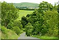
The Glen Road near Katesbridge
A minor road running SE from Kilkinamurry. Deehommed Mountain is in the background.
Image: © Albert Bridge
Taken: 20 Jul 2008
0.08 miles
2
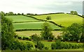
Drumlin country (23)
Lesser drumlins between Corbally and Kilkinamurry to the east of Banbridge.
Image: © Albert Bridge
Taken: 12 Jun 2008
0.10 miles
3
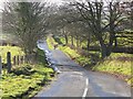
Corbally Road
Looking south from the crossroads
Image: © HENRY CLARK
Taken: 27 Nov 2008
0.13 miles
4
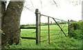
Gate near Katesbridge
This gate is on the Corbally Road Image close to where it meets the Lough and Glen Roads.
Image: © Albert Bridge
Taken: 4 May 2008
0.14 miles
5
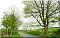
The Corbally Road near Katesbridge
One of many minor roads in the area, the Corbally Road runs from Shanrod in the direction of Closkelt.
Image: © Albert Bridge
Taken: 4 May 2008
0.14 miles