IMAGES TAKEN NEAR TO
School Road, BANBRIDGE, BT32 5JF
Introduction
This page details the photographs taken nearby to School Road, BT32 5JF by members of the Geograph project.
The Geograph project started in 2005 with the aim of publishing, organising and preserving representative images for every square kilometre of Great Britain, Ireland and the Isle of Man.

There are currently over 7.5m images from over14,400 individuals and you can help contribute to the project by visiting https://www.geograph.org.uk
Image Map
Images are licensed for reuse under creativecommons.org/licenses/by-sa/2.0
Notes
- Clicking on the map will re-center to the selected point.
- The higher the marker number, the further away the image location is from the centre of the postcode.
Image Listing (8 Images Found)
Images are licensed for reuse under creativecommons.org/licenses/by-sa/2.0
Image
Details
Distance
1
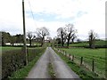
The southern end of The Green Road
The road here approaches the junction with School Road. This tarred section of the Green Road is also a farm road.
Image: © Eric Jones
Taken: 4 May 2013
0.02 miles
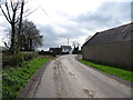
2
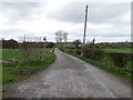
Private farm lane with access for pedestrians
This links with the green roads around Annahinchigo Lake.
Image]
Image: © Eric Jones
Taken: 4 May 2013
0.03 miles
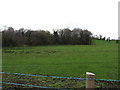
3
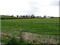
Farmland west of School Road
The image is taken from the Green Road
Image: © Eric Jones
Taken: 4 May 2013
0.07 miles
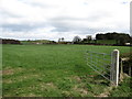
5
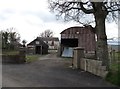
Disused farm buildings on School Road, Lisnisk TD
Image: © Eric Jones
Taken: 4 May 2013
0.15 miles
8
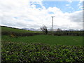
11kv power lines south-east of School Road
Image: © Eric Jones
Taken: 4 May 2013
0.22 miles