IMAGES TAKEN NEAR TO
Seafin Lane, BANBRIDGE, BT32 5ET
Introduction
This page details the photographs taken nearby to Seafin Lane, BT32 5ET by members of the Geograph project.
The Geograph project started in 2005 with the aim of publishing, organising and preserving representative images for every square kilometre of Great Britain, Ireland and the Isle of Man.

There are currently over 7.5m images from over14,400 individuals and you can help contribute to the project by visiting https://www.geograph.org.uk
Image Map
Images are licensed for reuse under creativecommons.org/licenses/by-sa/2.0
Notes
- Clicking on the map will re-center to the selected point.
- The higher the marker number, the further away the image location is from the centre of the postcode.
Image Listing (3 Images Found)
Images are licensed for reuse under creativecommons.org/licenses/by-sa/2.0
Image
Details
Distance
1
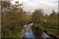
The River Bann near Ballyroney (1)
This is the Bann from the bridge on the Seafin Road near Ballyroney (between Ballyroney and Katesbridge). This view is looking downstream.
Image: © Albert Bridge
Taken: 8 Nov 2006
0.16 miles
2
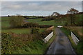
Bridge near Ballyroney
See Image This is the bridge on the Seafin Road (looking towards Ballyroney) over the Bann. It dates from 1878. The grid line runs through the parapet on the right. The name “Seafin” came into use around the mid-17th century. Before then the area was known as “Castle MacCoole”. The “MacCoole” being the big fella from north Antrim who was fond of a stroll over to Scotland. It seems that he also built a castle near here.
Image: © Albert Bridge
Taken: 8 Nov 2006
0.16 miles
3
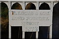
Bridge, River Bann near Ballyroney (detail)
See Image This is the foundry’s plate attached to the northern parapet of the bridge.
Image: © Albert Bridge
Taken: 8 Nov 2006
0.16 miles