IMAGES TAKEN NEAR TO
Cavehill Lane, BANBRIDGE, BT32 5DE
Introduction
This page details the photographs taken nearby to Cavehill Lane, BT32 5DE by members of the Geograph project.
The Geograph project started in 2005 with the aim of publishing, organising and preserving representative images for every square kilometre of Great Britain, Ireland and the Isle of Man.

There are currently over 7.5m images from over14,400 individuals and you can help contribute to the project by visiting https://www.geograph.org.uk
Image Map
Images are licensed for reuse under creativecommons.org/licenses/by-sa/2.0
Notes
- Clicking on the map will re-center to the selected point.
- The higher the marker number, the further away the image location is from the centre of the postcode.
Image Listing (8 Images Found)
Images are licensed for reuse under creativecommons.org/licenses/by-sa/2.0
Image
Details
Distance
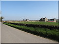
1
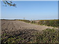
Ploughed land on the north side of Ballynafern Road
Image: © Eric Jones
Taken: 28 Mar 2012
0.10 miles
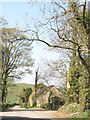
2
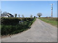
Cavehill Lane at its junction with Ballynafern Road
Image: © Eric Jones
Taken: 28 Mar 2012
0.11 miles
3
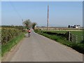
A cyclist on Ballynafern Road
Being largely free of traffic, the by-ways of Co Down are excellent cycling routes. Yet, this cyclist was the only one I encountered on a whole days walk. Here, she is passing the junction with Cavehill Road.
Image: © Eric Jones
Taken: 28 Mar 2012
0.14 miles
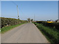
5
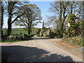
Cross roads on Cavehill Lane
The two lanes accessed from Cavehill Lane are private farm roads.
Image: © Eric Jones
Taken: 28 Mar 2012
0.17 miles
7
Modern detached houses on the Ballynafern Road
Image: © Eric Jones
Taken: 28 Mar 2012
0.20 miles
8
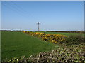
An 11kv power line and a whin hedge north of Ballynafern Road
Whin hedges are common in the drumlin country of Co Down.
Image: © Eric Jones
Taken: 28 Mar 2012
0.25 miles