IMAGES TAKEN NEAR TO
Glaskerbeg Road, BANBRIDGE, BT32 5BY
Introduction
This page details the photographs taken nearby to Glaskerbeg Road, BT32 5BY by members of the Geograph project.
The Geograph project started in 2005 with the aim of publishing, organising and preserving representative images for every square kilometre of Great Britain, Ireland and the Isle of Man.

There are currently over 7.5m images from over14,400 individuals and you can help contribute to the project by visiting https://www.geograph.org.uk
Image Map
Images are licensed for reuse under creativecommons.org/licenses/by-sa/2.0
Notes
- Clicking on the map will re-center to the selected point.
- The higher the marker number, the further away the image location is from the centre of the postcode.
Image Listing (4 Images Found)
Images are licensed for reuse under creativecommons.org/licenses/by-sa/2.0
Image
Details
Distance
1
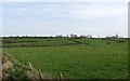
View across farmland to settlements on the Glaskerbeg Road
Image: © Eric Jones
Taken: 24 Mar 2012
0.09 miles
2
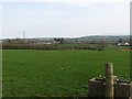
Farms on the Glaskerbeg Road
The Mourne Mountains can be seen in the far distance.
Image: © Eric Jones
Taken: 24 Mar 2012
0.22 miles
3
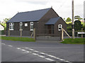
Annabane Mission Hall
Located on the junction of the Tierney Road and the Glaskerbeg Road
Image: © Terry Stewart
Taken: 26 Aug 2007
0.23 miles
4
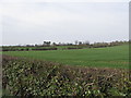
View across fields of cultivated grass to houses on the Glaskerbeg Road
Image: © Eric Jones
Taken: 24 Mar 2012
0.24 miles