IMAGES TAKEN NEAR TO
New Line, BANBRIDGE, BT32 5BG
Introduction
This page details the photographs taken nearby to New Line, BT32 5BG by members of the Geograph project.
The Geograph project started in 2005 with the aim of publishing, organising and preserving representative images for every square kilometre of Great Britain, Ireland and the Isle of Man.

There are currently over 7.5m images from over14,400 individuals and you can help contribute to the project by visiting https://www.geograph.org.uk
Image Map
Images are licensed for reuse under creativecommons.org/licenses/by-sa/2.0
Notes
- Clicking on the map will re-center to the selected point.
- The higher the marker number, the further away the image location is from the centre of the postcode.
Image Listing (4 Images Found)
Images are licensed for reuse under creativecommons.org/licenses/by-sa/2.0
Image
Details
Distance
1
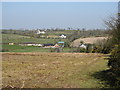
View from Imdale Cross road to houses in the Lisnacreevy Townland
This is an area of dispersed settlement set in a drumlin landscape.
Image: © Eric Jones
Taken: 28 Mar 2012
0.03 miles
2
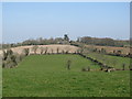
Lisnacreevy House, Lisnacreevy Townland
This image was taken from the Imdale Cross road. Lisnascreevy House stands on the crest of a drumlin.
Image: © Eric Jones
Taken: 28 Mar 2012
0.19 miles
3
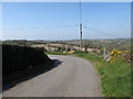
Acute bend in the Imdale Cross road
The view from here is dominated by a swarm of drumlins.
Image: © Eric Jones
Taken: 28 Mar 2012
0.24 miles
4
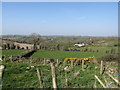
Houses on the Ballynamagna Road viewed from the Imdale Cross road
These houses are dotted in a drumlin topography.
Image: © Eric Jones
Taken: 28 Mar 2012
0.25 miles