IMAGES TAKEN NEAR TO
Rowanvale, BANBRIDGE, BT32 4RU
Introduction
This page details the photographs taken nearby to Rowanvale, BT32 4RU by members of the Geograph project.
The Geograph project started in 2005 with the aim of publishing, organising and preserving representative images for every square kilometre of Great Britain, Ireland and the Isle of Man.

There are currently over 7.5m images from over14,400 individuals and you can help contribute to the project by visiting https://www.geograph.org.uk
Image Map
Images are licensed for reuse under creativecommons.org/licenses/by-sa/2.0
Notes
- Clicking on the map will re-center to the selected point.
- The higher the marker number, the further away the image location is from the centre of the postcode.
Image Listing (3 Images Found)
Images are licensed for reuse under creativecommons.org/licenses/by-sa/2.0
Image
Details
Distance
1
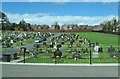
The Catholic Cemetery in Dromore Street, Banbridge
Image: © Eric Jones
Taken: 2 Apr 2011
0.24 miles
2
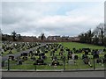
Seapatrick Parish Catholic Cemetery on Dromore Road
The land for a parish cemetery was purchased in 1872. It was extended in 1970.
Image: © Eric Jones
Taken: 3 Apr 2017
0.24 miles
3
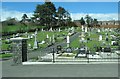
The Catholic Cemetery in Dromore Street, Banbridge
Image: © Eric Jones
Taken: 2 Apr 2011
0.24 miles