IMAGES TAKEN NEAR TO
Weavers Court, BANBRIDGE, BT32 4RP
Introduction
This page details the photographs taken nearby to Weavers Court, BT32 4RP by members of the Geograph project.
The Geograph project started in 2005 with the aim of publishing, organising and preserving representative images for every square kilometre of Great Britain, Ireland and the Isle of Man.

There are currently over 7.5m images from over14,400 individuals and you can help contribute to the project by visiting https://www.geograph.org.uk
Image Map
Images are licensed for reuse under creativecommons.org/licenses/by-sa/2.0
Notes
- Clicking on the map will re-center to the selected point.
- The higher the marker number, the further away the image location is from the centre of the postcode.
Image Listing (159 Images Found)
Images are licensed for reuse under creativecommons.org/licenses/by-sa/2.0
Image
Details
Distance
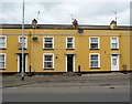
2
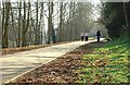
Riverside housing, Banbridge
Houses on the banks of the Bann with Weavers Court (left) built on the site of Ferguson’s weaving factory. Church Street Image is marked by the line of white houses (middle right) and Ballymoney Hill Image is at the top.
Image: © Albert Bridge
Taken: 5 Mar 2009
0.02 miles
3

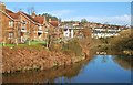
Old railway path, Banbridge
See Image An autumn view along the old railway just before the site of the junction of the lines to Scarva (ahead) and Knockmore Jct (right).
Image: © Albert Bridge
Taken: 1 Nov 2008
0.04 miles
4
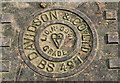
Manhole cover, Banbridge
Davidson & Co Ltd cover on the path behind what used to be the Water Board offices. It shows the kitemark and the British Standard number 497 -“Specification for manhole covers, road gully gratings and frames for drainage purposes. Cast iron and cast steel”
Image: © Albert Bridge
Taken: 24 Jul 2010
0.05 miles
5
Old railway path, Banbridge (2)
Image showed the path in autumn. There were signs of Spring today – a warm sun, bees, buds opening to leaves and lesser celandine growing in profusion.
Image: © Albert Bridge
Taken: 18 Mar 2009
0.06 miles
6
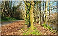
Spring, Banbridge
By tradition, the warm side of the stone Image turns up after St Patrick’s Day. It did this year and brought many out for a stroll along the old railway path by the Bann.
Image: © Albert Bridge
Taken: 18 Mar 2009
0.07 miles
7
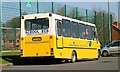
Minibus, Banbridge
A Mercedes mini-bus, in the livery of the Southern Education and Library Board, outside the leisure centre on the Downshire Road.
Image: © Albert Bridge
Taken: 18 Mar 2009
0.07 miles
8
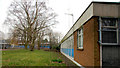
Former Water Board offices, Banbridge
The offices, on the Downshire Road, of the old Portadown and Banbridge Regional Waterworks Joint Board (later the DoE Water Service) – now closed.
Image: © Albert Bridge
Taken: 4 Mar 2011
0.07 miles
9
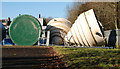
Conical objects, Banbridge
In the old DoE/Water Board yard on the Downshire Road. Might be silos or oversize septic tanks or . . . .
Image: © Albert Bridge
Taken: 30 Jan 2010
0.07 miles
10
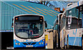
Bus, Banbridge (2)
An Ulsterbus Wrightbus Solar-bodied Scania inside Banbridge depot Image
Image: © Albert Bridge
Taken: 30 Jan 2010
0.08 miles