IMAGES TAKEN NEAR TO
Castlewellan Road, BANBRIDGE, BT32 4JP
Introduction
This page details the photographs taken nearby to Castlewellan Road, BT32 4JP by members of the Geograph project.
The Geograph project started in 2005 with the aim of publishing, organising and preserving representative images for every square kilometre of Great Britain, Ireland and the Isle of Man.

There are currently over 7.5m images from over14,400 individuals and you can help contribute to the project by visiting https://www.geograph.org.uk
Image Map
Images are licensed for reuse under creativecommons.org/licenses/by-sa/2.0
Notes
- Clicking on the map will re-center to the selected point.
- The higher the marker number, the further away the image location is from the centre of the postcode.
Image Listing (11 Images Found)
Images are licensed for reuse under creativecommons.org/licenses/by-sa/2.0
Image
Details
Distance
1

The Castlewellan Road, Banbridge (3)
See Image The Castlewellan Road, at Ballydown, looking towards Lisnaree and Castlewellan. This is close to the end of the straight part of the road. Thereafter (with the exception of the Katesbridge bypass) the road twists and turns with great frequency as it passes through drumlin country and into hill country close to the Mournes.
Image: © Albert Bridge
Taken: 14 Nov 2010
0.06 miles
2
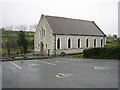
Ballydown Presbyterian Church
Rebuilt in 1904.
Image: © Brian Shaw
Taken: 1 Dec 2005
0.16 miles
3
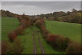
Old railway at Lisnaree near Banbridge (1)
The GNR(I) line from Knockmore Jct. to Castlewellan closed in 1955. This is the section of line at Lisnaree near Banbridge, looking towards Castlewellan. The course of the line is still very clear from the two rows of bushes.
Image: © Albert Bridge
Taken: 11 Nov 2006
0.16 miles
4
Old railway at Lisnaree near Banbridge (2)
See Image This is the view towards Banbridge and Knockmore Jct. The trackbed in the foreground has been incorporated into the adjoining farm but the course of the line is still clear at the middle top of the photo.
Image: © Albert Bridge
Taken: 11 Nov 2006
0.16 miles
5
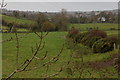
The Lisnaree Road near Banbridge
The Lisnaree Road is an unclassified road running from the Banbridge-Rathfriland road to the Banbridge-Castlewellan road. It runs through the Co. Down drumlins and does its share of twisting and turning in the process. This is the view to where it joins the road to Castlewellan. The pink building at top right is something which you probably thought did not exist – a new rural school!! See Image
Image: © Albert Bridge
Taken: 11 Nov 2006
0.16 miles
6
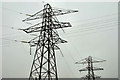
Pylons and power lines, Banbridge (1)
Two of the pylons (not shown on the OS map) at the bulk supply point substation at Ballydown. Continue to Image
Image: © Albert Bridge
Taken: 14 Nov 2010
0.20 miles
7
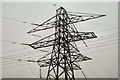
Pylons and power lines, Banbridge (2)
Image: © Albert Bridge
Taken: 14 Nov 2010
0.20 miles
8
Pillar box, Banbridge
GR pillar box (BT32 6) on the Castlewellan Road. This photograph, taken from the public road, appears as a matter of geographical and historical record only and is not intended to pose a risk to security.
Image: © Albert Bridge
Taken: 20 Jul 2013
0.22 miles
9
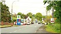
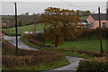
The Castlewellan Road, Banbridge (1)
The view towards Castlewellan from near the Ballydown crossroads with the Ballydown petrol station at middle left. This is outside the present developed part of the town – but for how long? See also Image
Image: © Albert Bridge
Taken: 19 May 2009
0.23 miles
10
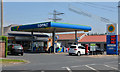
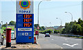
Petrol station, Banbridge
A long-established petrol station, modernised from its original form, on the Castlewellan Road. This photograph, taken from the public road, appears as a matter of geographical and historical record only http://www.geograph.org.uk/tagged/petrol+station#photo=3496022 and is not intended to pose a risk to security. This pillar box Image can be seen towards the lower right.
Image: © Albert Bridge
Taken: 20 Jul 2013
0.23 miles