IMAGES TAKEN NEAR TO
Laws Lane, BANBRIDGE, BT32 4JE
Introduction
This page details the photographs taken nearby to Laws Lane, BT32 4JE by members of the Geograph project.
The Geograph project started in 2005 with the aim of publishing, organising and preserving representative images for every square kilometre of Great Britain, Ireland and the Isle of Man.

There are currently over 7.5m images from over14,400 individuals and you can help contribute to the project by visiting https://www.geograph.org.uk
Image Map
Images are licensed for reuse under creativecommons.org/licenses/by-sa/2.0
Notes
- Clicking on the map will re-center to the selected point.
- The higher the marker number, the further away the image location is from the centre of the postcode.
Image Listing (9 Images Found)
Images are licensed for reuse under creativecommons.org/licenses/by-sa/2.0
Image
Details
Distance
1
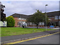
Southern Regional College, Banbridge Campus
The Southern Regional College was formed in 2007 with the amalgamation of the Upper Bann Institute (Lurgan, Portadown and Banbridge), Newry & Kilkeel Institute and Armagh Institute. They're all Further Education colleges of 'techs' as is still heard in Northern Ireland. The SRC in Banbridge, as it has been for many years, is on the Castlewellan Road. See also: Image
Image: © Dean Molyneaux
Taken: 5 Sep 2009
0.17 miles
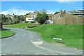
2
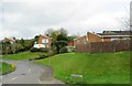
Richmond Heights at its junction with Dromore Street, Banbridge
This is part of the eastern suburbs of Banbridge.
Image: © Eric Jones
Taken: 3 Apr 2017
0.18 miles
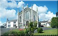
4
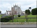
St Patrick's Catholic Chapel, Banbridge
Situated on the Dromore Street, this chapel dates from the 1830s.
Image: © Eric Jones
Taken: 3 Apr 2017
0.19 miles
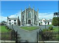
6
St Patrick's Roman Catholic Church, Dromore Street, Banbridge
This church dates from 1839.
Image: © Eric Jones
Taken: 26 Aug 2011
0.20 miles
7
St Patrick's Catholic Church and Presbytery
This church dates from the mid 19thC.
Image: © Eric Jones
Taken: 2 Apr 2011
0.21 miles
8
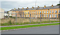
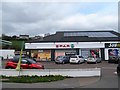
Vacant site, Banbridge
A vacant site, formerly Wrights’ Ford showroom, at the corner of Dromore Street and the Burn Brae (foreground) offered for sale and described by the agent as “This site is being offered with the benefit of Full planning consent for: 7 No.Retail units 2 No . Ofiice Units 20. No. Apartmet [sic] 2 No. semi – detached houses”. This photograph appears as a matter of record only. I have no connection with any of the parties involved in the sale.
Image: © Albert Bridge
Taken: 12 Oct 2013
0.22 miles
9
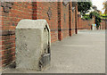
Milestone, Banbridge (2)
A surviving milestone (without the distance plate) on the Dromore Road at Ballyvally Heights - a remnant of the days when Banbridge was on the route of the Belfast – Dublin mail coach. Image (August 2010) shows the one on the Newry Road.
Image: © Albert Bridge
Taken: 15 Sep 2012
0.24 miles