IMAGES TAKEN NEAR TO
Ballydown Road, BANBRIDGE, BT32 4JB
Introduction
This page details the photographs taken nearby to Ballydown Road, BT32 4JB by members of the Geograph project.
The Geograph project started in 2005 with the aim of publishing, organising and preserving representative images for every square kilometre of Great Britain, Ireland and the Isle of Man.

There are currently over 7.5m images from over14,400 individuals and you can help contribute to the project by visiting https://www.geograph.org.uk
Image Map
Images are licensed for reuse under creativecommons.org/licenses/by-sa/2.0
Notes
- Clicking on the map will re-center to the selected point.
- The higher the marker number, the further away the image location is from the centre of the postcode.
Image Listing (44 Images Found)
Images are licensed for reuse under creativecommons.org/licenses/by-sa/2.0
Image
Details
Distance
1
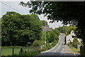
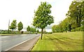
The Ballydown Road, Banbridge (1)
The Ballydown Road is an unclassified road running from the Rathfriland Road, over Lindsay's Bridge, to the Castlewellan Road. The old Ballydown Bleachworks is partly hidden by the trees on the left. This was once a quiet country road but is now close to being absorbed by the town.
Image: © Albert Bridge
Taken: 10 Jun 2006
0.03 miles
2
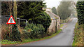
"Road narrows" sign, Banbridge
“Road narrows on the left” sign on the Ballydown Road Image approaching Lindsay’s Bridge Image from the Castlewellan Road Image
Image: © Albert Bridge
Taken: 14 Nov 2010
0.04 miles
3
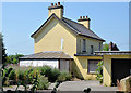
Vacant house, Banbridge (2013)
See Image (November 2010). The same house, still vacant and undeveloped, now with the weeds starting to appear above the wall.
Image: © Albert Bridge
Taken: 20 Jul 2013
0.04 miles
4
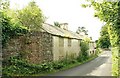
Vacant houses, Ballydown, Banbridge (1)
Two vacant (and blocked up) houses on the Ballydown Road with Lindsay’s Bridge Image in the background. See also Image
Image: © Albert Bridge
Taken: 4 Jul 2009
0.05 miles
5
The Castlewellan Road, Banbridge (2)
Image: © Albert Bridge
Taken: 19 May 2009
0.05 miles
6

Direction signs, Banbridge
Image: © Albert Bridge
Taken: 14 Nov 2010
0.05 miles
7
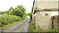
Vacant houses, Ballydown, Banbridge (2)
See Image The same houses (looking in the opposite direction) showing how close they (and their rooms) were to the road. This encouraged many a youthful cyclist (say 45 years ago) to slow down for a wee skelly.
Image: © Albert Bridge
Taken: 4 Jul 2009
0.05 miles
8
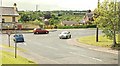
Ballydown crossroads, Banbridge
The staggered crossroads at Ballydown. The Banbridge (right) – Castlewellan road Image runs across the photo. The Old Manse Road Image is in the foreground and the Ballydown Road Image in the background.
Image: © Albert Bridge
Taken: 19 May 2009
0.06 miles
9
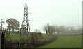
Pylons and power lines, Banbridge (4)
See Image This is the next one, near Lindsay’s Bridge and the Ballydown Road Image, to the south west.
Image: © Albert Bridge
Taken: 14 Nov 2010
0.08 miles
10
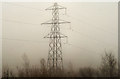
Pylons and power lines, Banbridge (3)
After crossing the Castlewellan Road the lines Image reach this (very misty) pylon. Continue to Image
Image: © Albert Bridge
Taken: 14 Nov 2010
0.08 miles