IMAGES TAKEN NEAR TO
Kilmacrew Road, BANBRIDGE, BT32 4EP
Introduction
This page details the photographs taken nearby to Kilmacrew Road, BT32 4EP by members of the Geograph project.
The Geograph project started in 2005 with the aim of publishing, organising and preserving representative images for every square kilometre of Great Britain, Ireland and the Isle of Man.

There are currently over 7.5m images from over14,400 individuals and you can help contribute to the project by visiting https://www.geograph.org.uk
Image Map
Images are licensed for reuse under creativecommons.org/licenses/by-sa/2.0
Notes
- Clicking on the map will re-center to the selected point.
- The higher the marker number, the further away the image location is from the centre of the postcode.
Image Listing (12 Images Found)
Images are licensed for reuse under creativecommons.org/licenses/by-sa/2.0
Image
Details
Distance
1
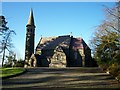
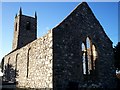
Magherally Parish Church, Kilmacrew Road, Banbridge
Also known locally as "The Church on the Hill" to distinguish it from Magherally Presbyterian church which is also known locally as "The Valley" church.
Image: © P Flannagan
Taken: 25 Feb 2008
0.07 miles
2
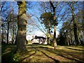
The Rectory of Magherally Parish Church
Image: © P Flannagan
Taken: 24 Feb 2008
0.08 miles
3
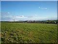
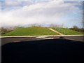
Landscape at The Cut, Kilmacrew Road, Banbridge
Image: © P Flannagan
Taken: 24 Feb 2008
0.11 miles
4
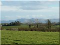
View of the Mountains of Mourne, Kilmacrew Road, Banbridge
Image: © P Flannagan
Taken: 24 Feb 2008
0.14 miles
6
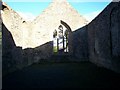
Interior , Old Magherally Parish Church, Kilmacrew Road, Banbridge
Image: © P Flannagan
Taken: 24 Feb 2008
0.18 miles
7
Ruins of Church, Kilmacrew Road, Banbridge
A new church has been built a short distance away from this old building for Magherally Parish. The graveyard is still being used beside this old church.
Image: © P Flannagan
Taken: 24 Feb 2008
0.18 miles
8
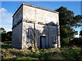
Old Water Tower
Constructed by the former Portadown and Banbridge Regional Waterworks Board, formed in 1946, whose functions ceased with the re-organisation of local government in 1973. Portadown and Banbridge had been getting water from Fofany reservoir since 1906 and then Spelga reservoir, which was completed in 1957. Less than 15 years later, despite the protests of the Portadown people at the loss of their much-cherished pure Mourne water, the supply to Portadown was replaced by water from Lough Neagh. The Spelga water was diverted to Newry.
Image: © P Flannagan
Taken: 24 Feb 2008
0.20 miles
9
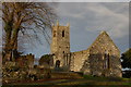
Magherally old church
The original parish church of Magherally was built in 1770 and abandoned in 1886 when replaced by a new church nearby. It is thought that the site dates back to mediaeval times. It is on the Kilmacrew Road.
Image: © Albert Bridge
Taken: 1 Jan 2007
0.24 miles
10
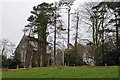
Magherally parish church near Banbridge
See Image This is the present parish church of St John the Evangelist. It replaced the old church.
Image: © Albert Bridge
Taken: 21 Mar 2007
0.24 miles