IMAGES TAKEN NEAR TO
Lurgan Road, BANBRIDGE, BT32 4AF
Introduction
This page details the photographs taken nearby to Lurgan Road, BT32 4AF by members of the Geograph project.
The Geograph project started in 2005 with the aim of publishing, organising and preserving representative images for every square kilometre of Great Britain, Ireland and the Isle of Man.

There are currently over 7.5m images from over14,400 individuals and you can help contribute to the project by visiting https://www.geograph.org.uk
Image Map
Images are licensed for reuse under creativecommons.org/licenses/by-sa/2.0
Notes
- Clicking on the map will re-center to the selected point.
- The higher the marker number, the further away the image location is from the centre of the postcode.
Image Listing (95 Images Found)
Images are licensed for reuse under creativecommons.org/licenses/by-sa/2.0
Image
Details
Distance
1
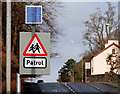
Solar panel, Banbridge
A solar panel powering flashing amber lights, on a “school” sign on the Lurgan Road.
Image: © Albert Bridge
Taken: 28 Feb 2010
0.06 miles
2
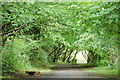
Old railway, Banbridge
The trackbed of the old railway from Banbridge to Scarva has been converted into a path. The photograph shows the path looking towards Scarva. Banbridge station was a few hundred yards behind the photographer. Continue to Image
Image: © Albert Bridge
Taken: 27 May 2006
0.07 miles
3
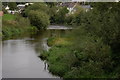
The Bann at Banbridge (1)
Banbridge takes its name from the bridge over the River Bann. This is the river (looking downstream) from the Water Bridge at the bottom of Bridge Street. The houses just to the right at the top are in Church Street.
Image: © Albert Bridge
Taken: 3 Sep 2006
0.07 miles
4
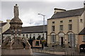
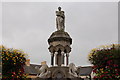
Crozier monument, Banbridge
Captain Francis Rawdon Moira Crozier, the son of a local solicitor, joined the navy and served on Franklin’s ill-fated expedition in search of the North West passage. He was born in 1796 and died in the expedition in 1848. This monument, in Church Square, was erected in 1862 to the design of WJ Barre. His birthplace was Avonmore House (the large house on the right of the photo). It is now, appropriately, a solicitor’s office.
Image: © Albert Bridge
Taken: 3 Sep 2006
0.07 miles
5
Crozier monument, Banbridge (detail)
See Image Crozier, surrounded by polar bears, is looking to the north west.
Image: © Albert Bridge
Taken: 3 Sep 2006
0.07 miles
6
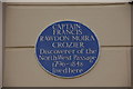
Crozier plaque, Banbridge
See Image This is the plaque on Avonmore House – Crozier’s birthplace.
Image: © Albert Bridge
Taken: 3 Sep 2006
0.07 miles
7
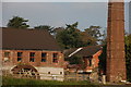
Former Cowdy's mill, Banbridge
See Image Cowdy’s has long since closed and the buildings are used by a number of businesses. This view is of the old waterwheel and its successor, the chimney, after conversion to steam power.
Image: © Albert Bridge
Taken: 15 Oct 2006
0.07 miles
8
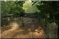
Old railway at Huntly, Banbridge
The GNR(I) line from Banbridge to Scarva closed in 1955. Shortly after leaving Banbridge the line crossed the River Bann by a bridge at Huntly before continuing past Cowdy’s mill to the level crossing at Millmount. This is the site of the bridge, now part of a riverside walk. The line of trees in the foreground shows the course of the railway clearly but it is not clear on the other side. Indeed, anyone not familiar with the area would find it hard to believe that a railway ever existed. Continue to Image
Image: © Albert Bridge
Taken: 15 Oct 2006
0.07 miles
9
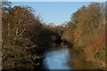
The Bann at Banbridge (2)
See Image This is the Bann a few hundred yards downstream of the previous photo. The vantage point was the site of the old railway station (now the leisure centre). The area is not quite as rural as it might appear – I positioned the camera carefully and zoomed to cut out the view of the houses built on the site of Ferguson’s weaving factory.
Image: © Albert Bridge
Taken: 26 Nov 2006
0.07 miles
10
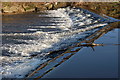
Weir, River Bann, Banbridge
Image: © Albert Bridge
Taken: 18 Feb 2007
0.07 miles