IMAGES TAKEN NEAR TO
Hillhead Gardens, BANBRIDGE, BT32 3XF
Introduction
This page details the photographs taken nearby to Hillhead Gardens, BT32 3XF by members of the Geograph project.
The Geograph project started in 2005 with the aim of publishing, organising and preserving representative images for every square kilometre of Great Britain, Ireland and the Isle of Man.

There are currently over 7.5m images from over14,400 individuals and you can help contribute to the project by visiting https://www.geograph.org.uk
Image Map
Images are licensed for reuse under creativecommons.org/licenses/by-sa/2.0
Notes
- Clicking on the map will re-center to the selected point.
- The higher the marker number, the further away the image location is from the centre of the postcode.
Image Listing (5 Images Found)
Images are licensed for reuse under creativecommons.org/licenses/by-sa/2.0
Image
Details
Distance
1
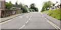
Fort Street, Banbridge
Fort Street runs south, off Newry Street and was once part of the old road to Newry and Dublin Image before being replaced by today’s Newry Road. The Newry Road was part of the Belfast – Newry turnpike. This area used to be known as “The Turnpike”.
Image: © Albert Bridge
Taken: 12 Aug 2010
0.24 miles
2
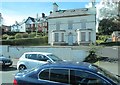
Boarded-up house on Newry Road
This has since been demolished.
Image
Image: © Eric Jones
Taken: 2 Apr 2011
0.24 miles
3
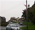
Loyalist emblems at the junction of Newry Road and Fort Street, Banbridge
Image: © Eric Jones
Taken: 6 Nov 2013
0.24 miles
4
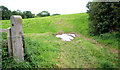
Surviving fields, Banbridge (4)
This one is on the western side of the Old Newry Road.
Image: © Albert Bridge
Taken: 12 Aug 2010
0.25 miles
5
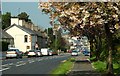
Cherry blossom, Banbridge
The last of the cherry blossom, on the Newry Road, looking towards Newry Street.
Image: © Albert Bridge
Taken: 7 May 2008
0.25 miles