IMAGES TAKEN NEAR TO
Ballievey Road, BANBRIDGE, BT32 3RX
Introduction
This page details the photographs taken nearby to Ballievey Road, BT32 3RX by members of the Geograph project.
The Geograph project started in 2005 with the aim of publishing, organising and preserving representative images for every square kilometre of Great Britain, Ireland and the Isle of Man.

There are currently over 7.5m images from over14,400 individuals and you can help contribute to the project by visiting https://www.geograph.org.uk
Image Map
Images are licensed for reuse under creativecommons.org/licenses/by-sa/2.0
Notes
- Clicking on the map will re-center to the selected point.
- The higher the marker number, the further away the image location is from the centre of the postcode.
Image Listing (16 Images Found)
Images are licensed for reuse under creativecommons.org/licenses/by-sa/2.0
Image
Details
Distance
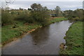
1
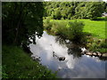
The Bann from Ballievey Bridge
The River Bann at Ballievey Bridge. The old G.N.R.(I) Knockmore Jct to Castlewellan railway ran along to the far right of this shot. It closed here in 1955.
Image: © Dean Molyneaux
Taken: 20 Jul 2009
0.05 miles
2
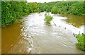
The Bann in flood (7)
See Image The Bann Image has broken its banks at Ballievey, flooding surrounding land. Continue to Image
Image: © Albert Bridge
Taken: 17 Aug 2008
0.05 miles
3
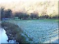
Townland of Ballievey
The River Bann at Ballievey
Image: © HENRY CLARK
Taken: 27 Dec 2008
0.09 miles
4
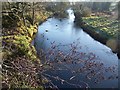
The River Bann at Ballievey
This is the River Bann (looking upstream) from the Ballievey Road bridge
Image: © HENRY CLARK
Taken: 27 Dec 2008
0.18 miles
5
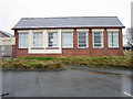
Former Ballydown Primary School
A new school has been recently built nearby.
Image: © Brian Shaw
Taken: 1 Dec 2005
0.20 miles
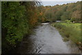
6
The River Bann at Ballievey near Banbridge (1)
This is the River Bann (looking upstream) from the Ballievey Road bridge. The river is higher than usual after two days of heavy rain.
Image: © Albert Bridge
Taken: 27 Oct 2006
0.20 miles
7
The River Bann at Ballievey near Banbridge (2)
See Image This is the view downstream.
Image: © Albert Bridge
Taken: 27 Oct 2006
0.20 miles
8
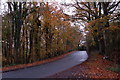
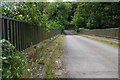
The Banbridge-Castlewellan road (2)
See Image This is the road at Chinauley, some two miles from Banbridge, looking towards the latter.
Image: © Albert Bridge
Taken: 11 Nov 2006
0.20 miles
9
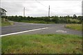
Ballievey crossroads near Banbridge
Ballievey crossroads on the Banbridge – Castlewellan road looking towards Castlewellan. The Drumneath Road is on the left and the Ballievey Road Image on the right.
Image: © Albert Bridge
Taken: 19 Aug 2007
0.20 miles
10
Ballievey Bridge near Banbridge
The original bridge across the Bann at Ballievey was a suspension bridge built in 1831/32. It collapsed in 1988 when a lorry exceeded the weight restriction. This is its successor. The view is away from the crossroads Image See Image for a view of the old bridge.
Image: © Albert Bridge
Taken: 25 Aug 2007
0.20 miles