IMAGES TAKEN NEAR TO
Dublin Road, BANBRIDGE, BT32 3NW
Introduction
This page details the photographs taken nearby to Dublin Road, BT32 3NW by members of the Geograph project.
The Geograph project started in 2005 with the aim of publishing, organising and preserving representative images for every square kilometre of Great Britain, Ireland and the Isle of Man.

There are currently over 7.5m images from over14,400 individuals and you can help contribute to the project by visiting https://www.geograph.org.uk
Image Map
Images are licensed for reuse under creativecommons.org/licenses/by-sa/2.0
Notes
- Clicking on the map will re-center to the selected point.
- The higher the marker number, the further away the image location is from the centre of the postcode.
Image Listing (35 Images Found)
Images are licensed for reuse under creativecommons.org/licenses/by-sa/2.0
Image
Details
Distance
1
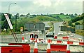
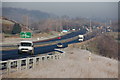
New flyover at Loughbrickland (2)
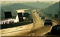
See Image Of the four flyovers now under construction south of Sprucefield, Loughbrickland is perhaps the most interesting. It provides a grade-separated junction at the Newry end of the bypass Image The contract includes the construction of hard shoulders, something which the existing road lacks. In practice it will be almost a complete rebuild of a road opened in 1973. It is not clear from the official material but it seems likely that right turns into Loughbrickland from the Banbridge end will be prohibited by closing the gap in the central reservation. Traffic from that direction will, presumably, use the new flyover instead. This is a view of the temporary arrangements at the Newry end of the bypass. Continue to Image
Image: © Albert Bridge
Taken: 6 Jul 2008
0.09 miles
2
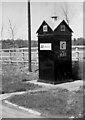
A A telephone box, Loughbrickland
Box no 645 used to stand, close to the main road, to the south of Loughbrickland. For those too young to remember such things Image will explain. Now gone but see Image
Image: © Albert Bridge
Taken: 5 May 1979
0.10 miles
3
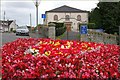
The Reformed Presbyterian Church, Loughbrickland
As far as I know the Reformed Presbyterian Church in Loughbrickland was built in 1817. It sits between Rathfriland Street (left) and the Dublin Road.
Image: © Albert Bridge
Taken: 8 Aug 2007
0.11 miles
4
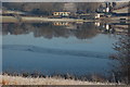
Loughbrickland lake near Banbridge (4)
See Image This is a similar view but with a heavy frost starting to clear. The fog but had changed to light mist. The temperature was below freezing point but the sky was almost cloudless. There is a coating of ice on the western shore but the rest of the lake is clear.
Image: © Albert Bridge
Taken: 7 Feb 2007
0.11 miles
5
Belfast-Dublin road near Loughbrickland (4)
See Image This is a similar view but with a heavy frost starting to clear. The fog but had changed to light mist. The temperature was below freezing point but the sky was cloudless.
Image: © Albert Bridge
Taken: 7 Feb 2007
0.11 miles
6
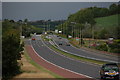
Belfast - Dublin road near Loughbrickland (2)
See Image This section of the road opened in 2005. This is the view towards Belfast where it joins the existing Loughbrickland bypass (note the absence of hard shoulders on the bypass).
Image: © Albert Bridge
Taken: 3 Sep 2006
0.11 miles
7
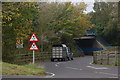
Underpass at Loughbrickland, Belfast-Dublin road
When the Loughbrickland bypass opened in the 70’s an underpass was thoughtfully provided to allow cattle to be moved to the milking parlour without having to cross the dual carriageway. Unfortunately the junction with the main road, for traffic leaving Loughbrickland southwards, proved to be the scene of many accidents. As a temporary measure, pending the building of a grade-separated junction, the underpass has been converted for use by vehicles. This is the view towards Loughbrickland. My apologies but I don’t know how the cattle now get to the milking!!
Image: © Albert Bridge
Taken: 20 Oct 2006
0.11 miles
8
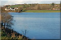
Loughbrickland lake near Banbridge (3)
See Image This is the section of the lake, is this square, seen from the embankment of the Belfast – Dublin road.
Image: © Albert Bridge
Taken: 8 Dec 2006
0.11 miles
9
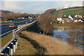
Belfast-Dublin road near Loughbrickland (3)
See Image I have included this photo, not as a duplicate, but to show how the new road has managed to avoid encroaching further upon Loughbrickland lake. The lake is on the right and the new road follows the line of the old.
See also Image
Image: © Albert Bridge
Taken: 8 Dec 2006
0.11 miles
10
New flyover, Loughbrickland (8)
See Image The view south (towards Newry and Dublin) just after the start of the temporary re-alignment of the existing road eastwards. I am standing in what was the northbound carriageway. Continue to Image
Image: © Albert Bridge
Taken: 31 Dec 2008
0.11 miles