IMAGES TAKEN NEAR TO
Newry Road, BANBRIDGE, BT32 3NE
Introduction
This page details the photographs taken nearby to Newry Road, BT32 3NE by members of the Geograph project.
The Geograph project started in 2005 with the aim of publishing, organising and preserving representative images for every square kilometre of Great Britain, Ireland and the Isle of Man.

There are currently over 7.5m images from over14,400 individuals and you can help contribute to the project by visiting https://www.geograph.org.uk
Image Map
Images are licensed for reuse under creativecommons.org/licenses/by-sa/2.0
Notes
- Clicking on the map will re-center to the selected point.
- The higher the marker number, the further away the image location is from the centre of the postcode.
Image Listing (3 Images Found)
Images are licensed for reuse under creativecommons.org/licenses/by-sa/2.0
Image
Details
Distance
1
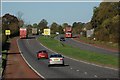
Approaching Banbridge from the south
The Dublin – Belfast road approaching Banbridge. There is still a 60mph speed limit on this section of road and it seems likely to stay until the flyover at the Dromore end of the bypass has been built and the gaps in the central reservation closed.
Image: © Albert Bridge
Taken: 15 Oct 2007
0.15 miles
2
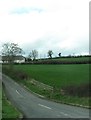
Springwell Loanin at its junction with the A1
Image: © Eric Jones
Taken: 2 Apr 2011
0.20 miles