IMAGES TAKEN NEAR TO
Summerhill, BANBRIDGE, BT32 3GG
Introduction
This page details the photographs taken nearby to Summerhill, BT32 3GG by members of the Geograph project.
The Geograph project started in 2005 with the aim of publishing, organising and preserving representative images for every square kilometre of Great Britain, Ireland and the Isle of Man.

There are currently over 7.5m images from over14,400 individuals and you can help contribute to the project by visiting https://www.geograph.org.uk
Image Map
Images are licensed for reuse under creativecommons.org/licenses/by-sa/2.0
Notes
- Clicking on the map will re-center to the selected point.
- The higher the marker number, the further away the image location is from the centre of the postcode.
Image Listing (3 Images Found)
Images are licensed for reuse under creativecommons.org/licenses/by-sa/2.0
Image
Details
Distance
1
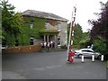
Belmont Hotel, Banbridge
We stopped briefly here for tea and scones
Image: © Kenneth Allen
Taken: 3 Aug 2009
0.18 miles
2
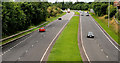
The Banbridge bypass (southbound)
The Banbridge bypass (looking towards Newry and Dublin) seen from the flyover Image on the Rathfriland Road. Note the closed gap in the central reservation at middle top.
Image: © Albert Bridge
Taken: 17 Jul 2010
0.18 miles
3
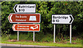
Road signs, Banbridge
Not quite “Welcome to Banbridge” but the signs greeting the northbound driver who turns off the bypass Image at the Rathfriland Road flyover Image
Image: © Albert Bridge
Taken: 17 Jul 2010
0.24 miles