IMAGES TAKEN NEAR TO
Commercial Road, BANBRIDGE, BT32 3ES
Introduction
This page details the photographs taken nearby to Commercial Road, BT32 3ES by members of the Geograph project.
The Geograph project started in 2005 with the aim of publishing, organising and preserving representative images for every square kilometre of Great Britain, Ireland and the Isle of Man.

There are currently over 7.5m images from over14,400 individuals and you can help contribute to the project by visiting https://www.geograph.org.uk
Image Map
Images are licensed for reuse under creativecommons.org/licenses/by-sa/2.0
Notes
- Clicking on the map will re-center to the selected point.
- The higher the marker number, the further away the image location is from the centre of the postcode.
Image Listing (189 Images Found)
Images are licensed for reuse under creativecommons.org/licenses/by-sa/2.0
Image
Details
Distance
2
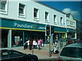
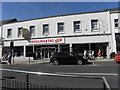
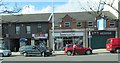
Poundland, Newry Street, Banbridge
This shop occupies the premises of the former Woolworth store.
Image: © Eric Jones
Taken: 26 Aug 2011
0.03 miles
4
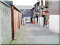
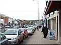
The Mall, Banbridge
The Mall is a pedestrian entry leading west from Newry Street to the car park on Commercial Road.
Image: © Dean Molyneaux
Taken: 10 Mar 2010
0.04 miles
6
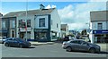
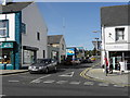
Linenhall Street, Banbridge
This is a short side street off Newry Street.
Image: © Eric Jones
Taken: 2 Apr 2011
0.04 miles
8
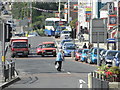
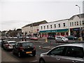
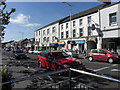
Newry Street, Banbridge
Through traffic occupies the middle lanes which go through The Cut.
Image]
Image: © Eric Jones
Taken: 6 Nov 2013
0.05 miles