1
Chimney Stack at Cowdy's Mill
The chimney stack of Cowdy's Linen Mill just before it was demolished. The River Bann around Banbridge was once lined with these mills.
Image: © Ciaran Mac Murchaidh
Taken: 21 Mar 2016
0.14 miles
2
Granville Gardens, Banbridge
The Northern Ireland Housing Trust was a body created to deal with the post-WWII housing shortage. A paper read by Sir Lucius O'Brien, (the Trust’s Chairman) on 20th March, 1953 included this: “The first report on housing in Northern Ireland, published in 1944 by the Housing Committee! of the Planning Advisory Board, revealed a serious state of affairs. The report estimated that 100,000 houses were needed immediately to provide reasonable housing conditions. The magnitude of such a figure may be judged by the fact that about 50,000 houses only, or an average of 2,500 per annum, were built between 1919 and 1939.”
The Trust supplemented the work of the numerous councils and often provided houses of a very high standard. Some might say that Granville was one of its best.
Image: © Albert Bridge
Taken: 28 Aug 2010
0.15 miles
3
St Teresa's Catholic Chapel, Scarva Road, Banbridge
Banbridge has three Catholic chapels. About a third of the population of the town are Roman Catholics.
Image: © Eric Jones
Taken: 6 Nov 2013
0.21 miles
4
Surviving fields, Banbridge (10)
Being grazed by sheep today. This field, on the southern side of the Scarva Road, was originally reserved for any future expansion of the factory on the left.
Image: © Albert Bridge
Taken: 28 Aug 2010
0.23 miles
5
Former gatelodge at Brookfield, Banbridge
Brookfield Mill (now closed) was owned by Smyth’s Weaving Company. The owner lived close to the mill. There were two gate lodges at the entrance on the Scarva Road. Both are now in a sorry state. This is the one on the eastern side of the entrance. At risk. For the view in 2010 see
Image
Image: © Albert Bridge
Taken: 3 Sep 2006
0.24 miles
6
Workhouse memorial, Banbridge (6 of 7)
See
Image Another sculpture shows the 13 names on the surviving page of the admission register for 10 January 1844. The page on the right shows how the building looked. Continue to
Image
Image: © Albert Bridge
Taken: 28 Feb 2010
0.24 miles
7
Workhouse memorial, Banbridge (7 of 7)
See
Image An extract from the page demonstrating the grim conditions prevalent at the time.
Image: © Albert Bridge
Taken: 28 Feb 2010
0.24 miles
8
Workhouse memorial, Banbridge (1 of 7)
An overall view of the memorial park showing the sculpture depicting a separated family. Continue to
Image
Image: © Albert Bridge
Taken: 28 Feb 2010
0.24 miles
9
Workhouse memorial, Banbridge (2 of 7)
See
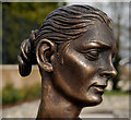
Image A close look at the mother. Continue to
Image
Image: © Albert Bridge
Taken: 28 Feb 2010
0.24 miles
10
Workhouse memorial, Banbridge (3 of 7)
See
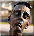
Image A close look at the son. Continue to
Image
Image: © Albert Bridge
Taken: 28 Feb 2010
0.24 miles


