IMAGES TAKEN NEAR TO
Underwood Terrace, BANBRIDGE, BT32 3DU
Introduction
This page details the photographs taken nearby to Underwood Terrace, BT32 3DU by members of the Geograph project.
The Geograph project started in 2005 with the aim of publishing, organising and preserving representative images for every square kilometre of Great Britain, Ireland and the Isle of Man.

There are currently over 7.5m images from over14,400 individuals and you can help contribute to the project by visiting https://www.geograph.org.uk
Image Map
Images are licensed for reuse under creativecommons.org/licenses/by-sa/2.0
Notes
- Clicking on the map will re-center to the selected point.
- The higher the marker number, the further away the image location is from the centre of the postcode.
Image Listing (204 Images Found)
Images are licensed for reuse under creativecommons.org/licenses/by-sa/2.0
Image
Details
Distance
1
Reilly Street, Banbridge
This image was taken from the corner of Victoria Street.
Image: © Eric Jones
Taken: 6 Nov 2013
0.03 miles
2
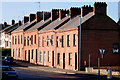
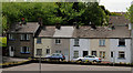
Underwood Terrace, Banbridge
Underwood Terrace is the last surviving row of houses from the Reilly Street of 100 years ago.
Image: © Albert Bridge
Taken: 30 Jan 2010
0.04 miles
3
Iveagh Gardens, Banbridge
Houses (shown as Iveagh Drive on the Google map) off Reilly Street. Built (as I remember) in the early 1970’s.
Image: © Albert Bridge
Taken: 28 Aug 2010
0.04 miles
4
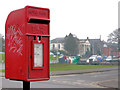
Letter box, Banbridge
Post-mounted EIIR letter box at the bottom of Reilly Street – visible at lower right in Image
Image: © Albert Bridge
Taken: 4 Mar 2011
0.05 miles
5
Railway Street, Banbridge
Railway Street once ran from Bridge Street Image to Reilly Street Image It had redbrick terrace houses, cottages, an undertaker, a bookie, the market yard, a shoe shop, a printer and a coal yard. This is what is left (Reilly Street end).
Image: © Albert Bridge
Taken: 31 May 2010
0.06 miles
6
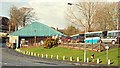
Bus depot, Banbridge
The Ulsterbus depot owes its position to the Great Northern Railway (Ireland) which, until the creation of the Northern Ireland Road Transport Board in 1935, operated buses alongside its railway services. The depot is adjacent to what was Banbridge railway station Image I doubt whether there are any remaining traces of the GNR’s depot.
Image: © Albert Bridge
Taken: 5 Mar 2009
0.06 miles
7
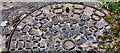
Pontamousson manhole cover, Banbridge
They might be common but this one, on the Downshire Road, is the first I have noticed. The following is an extract from the on line Britannica: “In 1970 Saint-Gobain merged with Pont-à-Mousson, a company founded in 1856 to produce pig iron and iron castings. By the time of the merger, Pont-à-Mousson had become a leader in metallurgy and the building trade.”
Image: © Albert Bridge
Taken: 4 Mar 2011
0.06 miles
8
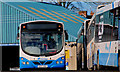
Bus, Banbridge (2)
An Ulsterbus Wrightbus Solar-bodied Scania inside Banbridge depot Image
Image: © Albert Bridge
Taken: 30 Jan 2010
0.06 miles
9
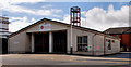
Fire station, Banbridge
Banbridge fire station in Victoria Street.
Image: © Albert Bridge
Taken: 28 Aug 2010
0.06 miles
10
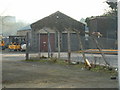
Former Engine Shed
What must be the only building left of the old GNR(I) railway line that ran through Banbridge until 1955.
It's the former engine shed that is now used by Ulster Bus, whose depot is on the site of the now demolished station. Easy to spot from the walk alongside the Ban river it is almost invisible from the Downshire road running alongside it.
Image: © Alistair McCann
Taken: 17 Dec 2007
0.07 miles