IMAGES TAKEN NEAR TO
Reilly Park, BANBRIDGE, BT32 3DJ
Introduction
This page details the photographs taken nearby to Reilly Park, BT32 3DJ by members of the Geograph project.
The Geograph project started in 2005 with the aim of publishing, organising and preserving representative images for every square kilometre of Great Britain, Ireland and the Isle of Man.

There are currently over 7.5m images from over14,400 individuals and you can help contribute to the project by visiting https://www.geograph.org.uk
Image Map
Images are licensed for reuse under creativecommons.org/licenses/by-sa/2.0
Notes
- Clicking on the map will re-center to the selected point.
- The higher the marker number, the further away the image location is from the centre of the postcode.
Image Listing (72 Images Found)
Images are licensed for reuse under creativecommons.org/licenses/by-sa/2.0
Image
Details
Distance
1
St Theresa's church, Banbridge
St Theresa’s (RC) church seen from the Edenderry Road - an attractive piece of modern ecclesiastical architecture benefiting from a corner site with the Scarva Road.
Image: © Albert Bridge
Taken: 21 Dec 2008
0.08 miles
2
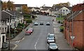
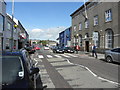
Reilly Street, Banbridge
Reilly Street seen from the Downshire Road. The street was rebuilt in the early 70’s. It was originally a street of small terrace houses and some cottages. The old gasworks was about half-way up the hill on the right.
Image: © Albert Bridge
Taken: 2 Nov 2007
0.09 miles
3
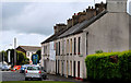
Edenderry Terrace, Banbridge
A terrace at the Scarva Street end of the Edenderry Road. Currently offered for sale as a site for apartments.
Image: © Albert Bridge
Taken: 28 Aug 2010
0.09 miles
4
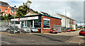
Car showroom, Banbridge
Now selling used cars, the showroom, on the Scarva Road, dates from the mid-1960’s when it was built as a Rootes Group dealership. The buildings in the background were once (if my memory is correct) part of the Silverford Ropeworks.
Image: © Albert Bridge
Taken: 28 Aug 2010
0.09 miles
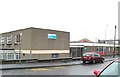
6
Banbridge Elim Pentecostal Church in Victoria Street
Image: © Eric Jones
Taken: 6 Nov 2013
0.10 miles
7
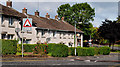
View west along Scarva Road, Banbridge
This is an area of new sub-urban housing estates.
Image: © Eric Jones
Taken: 6 Nov 2013
0.10 miles
8
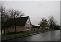
Iveagh Gardens, Banbridge
Houses (shown as Iveagh Drive on the Google map) off Reilly Street. Built (as I remember) in the early 1970’s.
Image: © Albert Bridge
Taken: 28 Aug 2010
0.11 miles
10
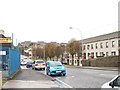
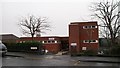
The Health and Social Services Centre, Banbridge
This is located in Scarva Road, next to the Banbridge Library.
Image: © Eric Jones
Taken: 6 Nov 2013
0.11 miles