IMAGES TAKEN NEAR TO
Brookfield Park, BANBRIDGE, BT32 3BU
Introduction
This page details the photographs taken nearby to Brookfield Park, BT32 3BU by members of the Geograph project.
The Geograph project started in 2005 with the aim of publishing, organising and preserving representative images for every square kilometre of Great Britain, Ireland and the Isle of Man.

There are currently over 7.5m images from over14,400 individuals and you can help contribute to the project by visiting https://www.geograph.org.uk
Image Map
Images are licensed for reuse under creativecommons.org/licenses/by-sa/2.0
Notes
- Clicking on the map will re-center to the selected point.
- The higher the marker number, the further away the image location is from the centre of the postcode.
Image Listing (32 Images Found)
Images are licensed for reuse under creativecommons.org/licenses/by-sa/2.0
Image
Details
Distance
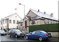
2
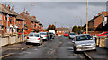
Peggy's Loanin, Banbridge (2)
See Image The view in the opposite direction (towards the Huntly Road). The long redbrick terrace on the right is Edenderry Gardens Image
Image: © Albert Bridge
Taken: 28 Feb 2010
0.09 miles
3
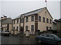
The Orange Hall, Victoria Street, Banbridge
Image: © Eric Jones
Taken: 6 Nov 2013
0.10 miles
4
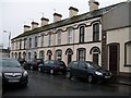
Victorian terrace next to Banbridge Orange Hall
The terrace is located half way along Victoria Street.
Image: © Eric Jones
Taken: 6 Nov 2013
0.12 miles
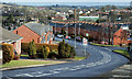
5
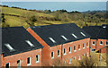
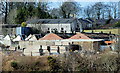
New houses, Banbridge (2)
See Image Another part of the new development of 60 social homes between Peggy’s Loanin and Brookfield Mill.
Image: © Albert Bridge
Taken: 28 Feb 2010
0.12 miles
6
Edenderry Park, Banbridge (2)
Image: © Albert Bridge
Taken: 28 Feb 2010
0.12 miles
7
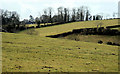
Surviving fields, Banbridge (1)
The view from near the bottom of Peggy’s Loanin with the end of existing housing just visible at top left.
Image: © Albert Bridge
Taken: 28 Feb 2010
0.16 miles
8
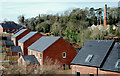
New houses, Banbridge (1)
Part of the new development of 60 social homes between Peggy’s Loanin and Brookfield Mill (top right). See also Image
Image: © Albert Bridge
Taken: 28 Feb 2010
0.16 miles
9
Former Brookfield Mill, Banbridge (3)
Image: © Albert Bridge
Taken: 28 Feb 2010
0.17 miles
10
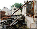
Former Brookfield mill, Banbridge (9)
See Image The roofless inside of one of the buildings.
Image: © Albert Bridge
Taken: 28 Aug 2010
0.18 miles